Friday, June 21st, 2019
Weather rages on
Area is hit by flooding
By Tom Stankard

Photo by Ryan Snyder/The Daily Standard
Once again, the area around U.S. 127 and Beaver Creek south of Celina is inundated by floodwaters. Some affected businesses are, clockwise from bottom: Romer's Catering, Westlake Village, The Boathouse at Grand Lake and Grand Lakeside Pub and Catering, which is in the former Breakaway RecPlex facility. The foam at the bottom shows Beaver Creek's usual channel.
Torrential rain poured onto Mercer and Auglaize counties causing widespread flooding Wednesday evening into Thursday.
Many property owners are coping once again with flooded fields, yards and basements not long after heavy rain fell on May 17.
Homes and fields in the Grand Lake Watershed in southern Mercer County were hit hardest with 5 inches of rain in some areas, Mercer County Emergency Management Agency Director Mike Robbins said.
Celina may have not been hit hard compared with other communities, but all the water flows into Grand lake, mayor Jeff Hazel said.
The lake's water level was 25 inches above the notch on the west bank, Grand Lake St. Marys Park Manager David Faler said.
The water level was expected to crest at about noon Thursday, Hazel noted, but the level kept rising and falling throughout the day.
Water crested over Beaver Creek's banks, forcing Mercer Health's Community Medical Center to remain closed until Sunday for the safety of patients and employees, said Mindy Kramer, vice president of development, marketing and communications.
Office suites are being relocated to Mercer County Community Hospital in Coldwater and Mercer Health Home Care facility in Celina. Further updates will be posted on mercer-health.com, she said.
Flooding in Montezuma is "a lot worse than it was the last time," fire chief Lee Bruns said.
"With the amount of rain we got as fast as it came, we couldn't handle it," Bruns said. "Water was a lot higher than it was before."
Homeowners used sandbags provided by the fire department to fend off the flood, which was beginning to recede Thursday afternoon, but Bruns said he knows of at least three homes that are still flooded. St. Marys safety service director Greg Foxhoven said "we're doing fairly well" as of 5 p.m. Thursday.
City officials and residents filled sandbags for residents before the rain fell as a precautionary measure to prevent flood damage, Foxhoven said.
"We're hopeful it worked," he said. "A lot of homeowners know what measures to take.
Compared with the May storm, Foxhoven said Wednesday's rainfall was not as bad, although water had risen over the St. Marys River's banks, causing the intersection of Hackney and McLain streets to remain closed.
Nearby, the water rose above the fences of baseball fields 9 and 10 at K.C. Geiger Park on the south side of the city.
Many area farmers are faced with flooded, unplanted fields containing soil that has not had a chance to dry along with possibly damaged crops in fields that have recently been planted, Auglaize County FSA Director Anita Green said.
Robbins wants to remind motorists not to drive into deep water.
Celina and Montezuma firefighters rescued at least three motorists who had been stranded.
Today's forecast includes a short break from rain, with partly cloudy skies predicted, local weatherman Dennis Howick said.
But he expects rain to return Saturday through Monday with scattered thunderstorms in the forecast and isolated storms for three more days after that.
"Folks are ready for all the rain to stop," Hazel said. "It is difficult for not only the homeowners but particularly for farmers. This adds insult to injury following the tornado and the flooding about a month ago. We're a community. We suffer when each other suffers."
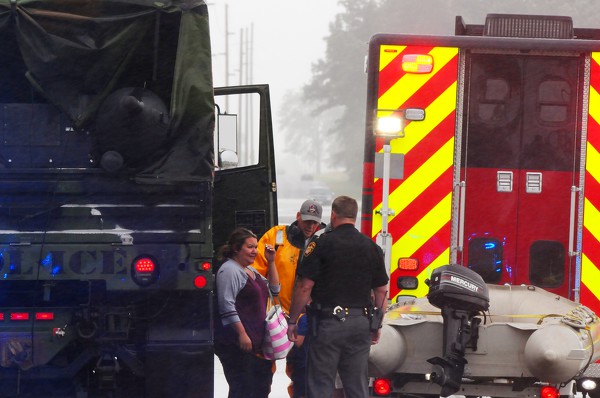
Photo by Ryan Snyder/The Daily Standard
A woman and child were rescued from their stranded minivan on Fleetfoot Road near Beaver Creek Thursday afternoon. Celina police and fire personnel used the police department's military cargo truck to drive the pair to safety.
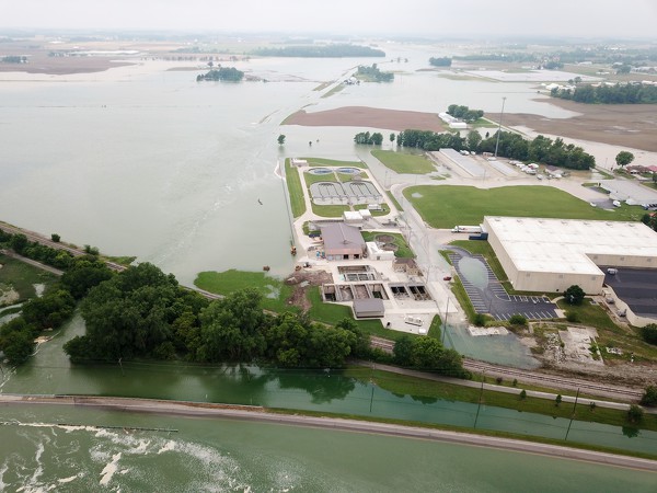
Photo by Ryan Snyder/The Daily Standard
Floodwaters approach the Celina sewage treatment plant. In the foreground is U.S. 127.

Photo by Dan Melograna/The Daily Standard
A Pontiac sedan plows slowly through the high waters along State Route 219 heading into Montezuma.
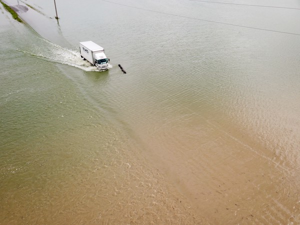
Photo by Ryan Snyder/The Daily Standard
A box truck passes a log southbound on the closed Fleetfoot Road near Beaver Creek. Later in the day a minivan was stranded in this location.

Photo by Dan Melograna/The Daily Standard
A killdeer looks for fresh food after flooding on Thursday on State Route 118 in Celina.
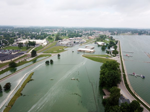
Photo by Ryan Snyder/The Daily Standard
In the foreground, the embankments of Celina's water treatment sludge settling ponds are overtopped by floodwater.
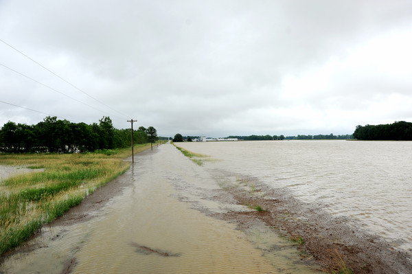
Photo by Dan Melograna/The Daily Standard
Carmel Church Road in Celina was closed due to flooding on Thursday morning.
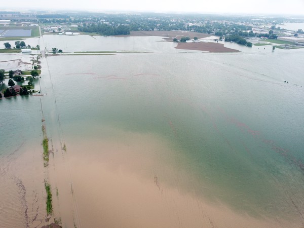
Photo by Ryan Snyder/The Daily Standard
Green water from Grand Lake mixes with brown water running off fields along Meyer Road, south of Celina.
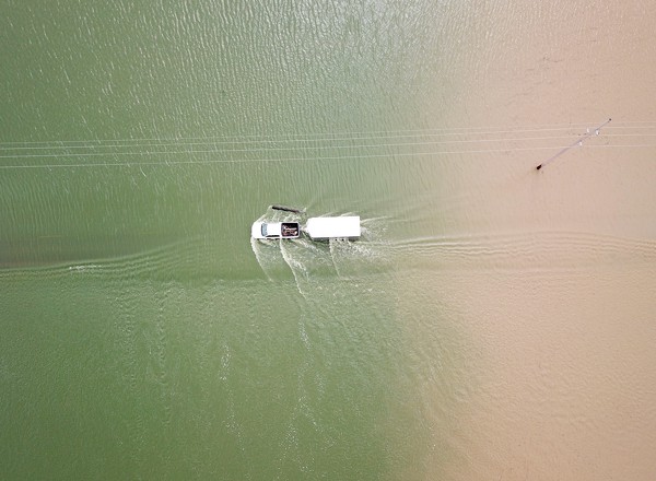
Photo by Ryan Snyder/The Daily Standard
A pickup truck pulls a trailer northbound on the closed Fleetfoot Road near Beaver Creek.
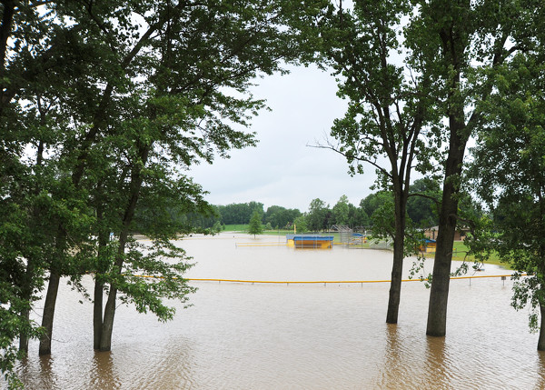
Photo by Dan Melograna/The Daily Standard
The St. Marys' softball field was flooded on Thursday morning in K.C. Geiger Park.

Photo by Dan Melograna/The Daily Standard
Farm fields along State Route 118 were flooded on Thursday afternoon in Celina.