Severe Thunderstorm Watch issued August 10 at 2:44PM EDT until August 10 at 8:00PM EDT by NWS Wilmington OH (details ...)
THE NATIONAL WEATHER SERVICE HAS EXTENDED SEVERE THUNDERSTORM WATCH 554 TO INCLUDE THE FOLLOWING AREAS UNTIL 8 PM EDT THIS EVENING
IN INDIANA THIS WATCH INCLUDES 8 COUNTIES
IN EAST CENTRAL INDIANA
FAYETTE UNION WAYNE
IN SOUTHEAST INDIANA
DEARBORN FRANKLIN OHIO RIPLEY SWITZERLAND
IN KENTUCKY THIS WATCH INCLUDES 11 COUNTIES
IN NORTHERN KENTUCKY
BOONE BRACKEN CAMPBELL CARROLL GALLATIN GRANT KENTON MASON OWEN PENDLETON ROBERTSON
IN OHIO THIS WATCH INCLUDES 27 COUNTIES
IN CENTRAL OHIO
DELAWARE FAIRFIELD FAYETTE FRANKLIN HOCKING LICKING MADISON PICKAWAY UNION
IN SOUTHWEST OHIO
BROWN BUTLER CLERMONT CLINTON HAMILTON WARREN
IN WEST CENTRAL OHIO
AUGLAIZE CHAMPAIGN CLARK DARKE GREENE HARDIN LOGAN MERCER MIAMI MONTGOMERY PREBLE SHELBY
THIS INCLUDES THE CITIES OF ABERDEEN, ADA, ALEXANDRIA, AUGUSTA, AURORA, BATESVILLE, BEAVERCREEK, BELLEFONTAINE, BELLEVUE, BLANCHESTER, BRIGHT, BROOKSVILLE, BROOKVILLE, BURLINGTON, BUTLER, CAMDEN, CARROLLTON, CELINA, CIRCLEVILLE, COLDWATER, CONNERSVILLE, COVINGTON, CRITTENDEN, DAY HEIGHTS, DAYTON, DELAWARE, DILLSBORO, DOWNTOWN CINCINNATI, DOWNTOWN COLUMBUS, DOWNTOWN DAYTON, DRY RIDGE, EATON, ERLANGER, FAIRBORN, FAIRFIELD, FALMOUTH, FLORENCE, FORT THOMAS, FRANKLIN, GEORGETOWN, GREENDALE, GREENVILLE, HAMILTON, HIDDEN VALLEY, HIGHLAND HEIGHTS, INDEPENDENCE, KENTON, KETTERING, LANCASTER, LANDEN, LAWRENCEBURG, LEBANON, LIBERTY, LOGAN, LONDON, MARYSVILLE, MASON, MAYSVILLE, MIDDLETOWN, MILAN, MILFORD, MINSTER, MOUNT CARMEL, MOUNT OLIVET, MOUNT ORAB, MOUNT REPOSE, MULBERRY, NEW BREMEN, NEWARK, NEWPORT, OAKBROOK, OSGOOD, OWENTON, OXFORD, PICKERINGTON, PIQUA, PLAIN CITY, RICHMOND, RIPLEY, RISING SUN, SIDNEY, SPRINGBORO, SPRINGFIELD, ST. MARYS, SUMMERSIDE, TIPP CITY, TROY, URBANA, VERSAILLES, VEVAY, WAPAKONETA, WARSAW, WASHINGTON COURT HOUSE, WEST COLLEGE CORNER, WEST JEFFERSON, WILLIAMSTOWN, WILMINGTON, WITHAMSVILLE, AND XENIA.
Flood Watch issued August 10 at 1:04PM EDT until August 12 at 8:00AM EDT by NWS Wilmington OH (details ...)
* WHAT...Flash flooding caused by excessive rainfall is possible.
* WHERE...Portions of Indiana, including the following counties, Dearborn, Fayette, Franklin, Union and Wayne, Kentucky, including the following counties, Boone, Bracken, Campbell, Kenton, Lewis, Mason, Pendleton and Robertson, and Ohio, including the following counties, Adams, Auglaize, Brown, Butler, Champaign, Clark, Clermont, Clinton, Darke, Delaware, Fairfield, Fayette, Franklin, Greene, Hamilton, Hardin, Highland, Hocking, Licking, Logan, Madison, Mercer, Miami, Montgomery, Pickaway, Pike, Preble, Ross, Scioto, Shelby, Union and Warren.
* WHEN...Through Wednesday morning.
* IMPACTS...Excessive runoff may result in flooding of rivers, creeks, streams, and other low-lying and flood-prone locations.
* ADDITIONAL DETAILS... - Several rounds of thunderstorms are expected through Tuesday night. Locally heavy rainfall can be expected with the potential for storms to repeatedly track over the same locations. This will result in the potential for flash flooding.
Today 84° Today 84° chance 68° 68° chance likely Tomorrow 82° Tomorrow 82° likely chance 67° 67° chance
Saturday, June 22nd, 2019

Rain totals rising up to historic level

By Tom Stankard
CELINA - Rainfall levels not seen in decades have accumulated in Celina over the past two months, local weatherman Dennis Howick said.
Celina residents in May endured rain accumulating to 7.28 inches, well above the 2.5-inch average, he said. Heavy rainfall has continued this month, having reached 3.99 inches so far, nearing the average of 4.07 inches for the entire month. However, he noted that other area locations had received much more rain this month than he had measured in northeastern Mercer County.   
Howick said he cannot remember rainfall levels like this since 1981. Rain has been accumulating at above-average rates since October.
Thanks to a short reprieve on Friday, Grand Lake and Beaver Creek have leveled off and are beginning to recede, Mercer County Emergency Management Agency Director Mike Robbins said.
Rainfall totals from Wednesday's storm varied from place to place, he added, noting some areas in the southern Grand Lake region were hit with upward of 5 inches.  
The sporadic rainfall caused water to collect in places he can't remember having been flooded before, as high water still stands on some major roadways.
He doesn't know when all roadways will reopen but hopes they will within the next day or so. Several motorists have driven around road closed and high water signs and attempted to drive through high water, only to get stuck, Celina Fire Lt. John Schumm said.
Since Wednesday's storm, he said the department has responded to six reports of vehicles stranded in high water. Three vehicles were stranded on Burkettsville-St. Henry road, where Beaver Creek flooded the roadway.
Beaver Creek flooding left two other vehicles stranded on Fleetfoot Road and another car near Schunck and Meyer roads, he added. Rescues have also occurred in St. Henry and Montezuma.
No motorists were injured, he said, and stressed "if you see the sign, don't just go around it." Although no one was injured, he said currents can be strong enough to sweep away vehicles into a field or ditch.
Montezuma Fire Chief Lee Bruns described the event as the worst flooding he has seen in a while. By Friday, however, the flooding had abated as water levels in Grand Lake's tributaries keeps receding.
A flood warning from the National Weather Service has been extended for Mercer and Auglaize counties until 1:45 p.m. today with more rain predicted for today and Sunday, according to Howick.
"It could flood again, it just depends on where the rain falls and how much we get," Robbins said.

Additional online stories on this date
  CELINA - Mercer County Health District Director of Nursing and Communicable Disease Coordinator Julia Shaffer is spreading the word about immunization rates in Mercer County as the national measles outbreak continues to spread. [More]
CELINA - The beer was flowing Friday night at Montgomery Field.
As for the Grand Lake Mariners, they sipped on sweet victory and also tasted bitter defeat. [More]
Subscriber and paid stories on this date
Governor to file new federal assistance plea
NEW WESTON - Ohio Agriculture Director Dorothy Pelanda met with area farmers on Friday morning to discuss the planting struggles created by this year's historic rainfall.
Bernard details history on St. Henry street
CINCINNATI - Allen Bernard left St. Henry long ago to pursue a college education and profession, but the village in which he grew up left an indelible stamp on his heart and mind.
COLUMBUS - Disaster Survivor Assistance specialists will be in the area soon to help tornado survivors.
The specialists will be canvasing the area
Cavs, Tribe split ACME doubleheader
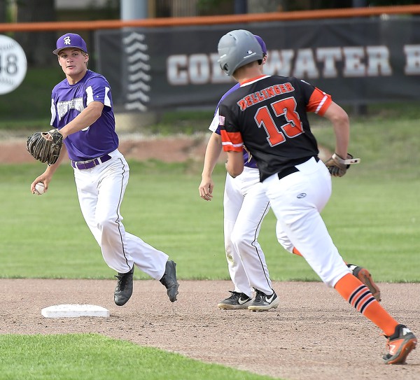
COLDWATER - Fort Recovery and Coldwater were scheduled to play two games in ACME baseball action on Friday night at Veterans Field.
The first game
Staff and Wire Reports
Fort Recovery graduate Nick Thwaits made his second start Thursday night for the Tri-City Dust Devils, the San Diego Padres' Class-A short-season affiliate of the Northwest League.
ACME Roundup
Compiled by Colin Foster
St. Henry's Ryan Uhlenhake was 'pitcher' perfect on Friday night.
Uhlenhake threw a perfect game - striking out 10 without issuing a walk in St. Henry's 14-0, five-inning win over Celina at the Wally Post Athletic Complex.