Flood Warning issued September 17 at 10:44AM EDT until September 17 at 4:45PM EDT by NWS Wilmington OH (details ...)
* WHAT...Flooding caused by excessive rainfall is expected.
* WHERE...Northwestern Auglaize County in west central Ohio... Mercer County in west central Ohio... Northwestern Shelby County in west central Ohio...
* WHEN...Until 445 PM EDT Thursday.
* IMPACTS...Flooding of rivers, creeks, streams, and other low-lying and flood-prone locations is imminent or occurring.
* ADDITIONAL DETAILS... - At 1044 AM EDT, radar indicated heavy rain due to thunderstorms. Flooding is ongoing or expected to begin shortly in the warned area. Between 2.5 and 3.5 inches of rain have fallen.Additional rainfall amounts up to 0.5 inches are possible in the warned area. - Some locations that may experience flooding include... Celina, St. Marys, Coldwater, New Bremen, Rockford, Wabash, Mendon, Chickasaw, Montezuma, Tama, Neptune, Carthagena, Bulkhead, State Route 116 at State Route 197, Chattanooga and Kossuth.
Today 83° Today 83° likely 67° 67° slight chance chance Tomorrow 77° Tomorrow 77° 62° 62°
Wednesday, May 27th, 2020
Photo by Dan Melograna/The Daily Standard

Anita Fleming and her daughter Deb stand outside their home at 4038 Mud Pike on Friday afternoon. Fleming's home was destroyed by the Memorial Day tornado a year ago today.

Related online story:

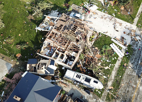
CELINA - Anita Fleming of Celina has few memories of the Memorial Day 2019 tornado that ravaged her Mud Pike property and left her unconscious for nearly a month at Miami Valley Hospital in Dayton, where she was treated for severe injuries. [More]
Additional pictures on this date