Flood Advisory issued August 12 at 10:55AM EDT until August 12 at 2:15PM EDT by NWS Wilmington OH (details ...)
* WHAT...Flooding caused by excessive rainfall continues.
* WHERE...Southwestern Auglaize County in west central Ohio... Darke County in west central Ohio... Mercer County in west central Ohio... Miami County in west central Ohio... Northeastern Preble County in west central Ohio... Western Shelby County in west central Ohio...
* WHEN...Until 215 PM EDT.
* IMPACTS...Minor flooding in low-lying and poor drainage areas.
* ADDITIONAL DETAILS... - At 1054 AM EDT, local law enforcement has reported minor flooding in the advisory area. Between 2 and 3 inches of rain have fallen. Additional rainfall amounts of 1 to 1.5 inches are possible. - Some locations that may experience flooding include... Troy, Piqua, Greenville, Celina, Tipp City, St. Marys, West Milton, Coldwater, New Bremen, Minster, Versailles, Covington, St. Henry, Arcanum, Newport, Bradford, Union City, Fort Loramie, Fort Recovery and Pleasant Hill.
Flood Watch issued August 12 at 9:17AM EDT until August 12 at 11:00PM EDT by NWS Wilmington OH (details ...)
* WHAT...Flash flooding caused by excessive rainfall continues to be possible.
* WHERE...Portions of Indiana, including the following counties, Dearborn, Fayette, Franklin, Ohio, Ripley, Switzerland, Union and Wayne, Kentucky, including the following counties, Boone, Bracken, Campbell, Carroll, Gallatin, Grant, Kenton, Lewis, Mason, Owen, Pendleton and Robertson, and Ohio, including the following counties, Adams, Auglaize, Brown, Butler, Champaign, Clark, Clermont, Clinton, Darke, Delaware, Fairfield, Fayette, Franklin, Greene, Hamilton, Hardin, Highland, Hocking, Licking, Logan, Madison, Mercer, Miami, Montgomery, Pickaway, Pike, Preble, Ross, Scioto, Shelby, Union and Warren.
* WHEN...Through this evening.
* IMPACTS...Excessive runoff may result in flooding of rivers, creeks, streams, and other low-lying and flood-prone locations.
* ADDITIONAL DETAILS... - Additional thunderstorms are expected into this evening. Locally heavy rainfall and the potential for storms to repeatedly track over the same areas are possible. This will result in the potential for flash flooding.
Today 83° Today 83° likely 68° 68° slight chance chance Tomorrow 81° Tomorrow 81° chance chance 68° 68° chance
Monday, June 21st, 2021
By William Kincaid
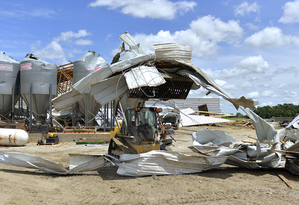
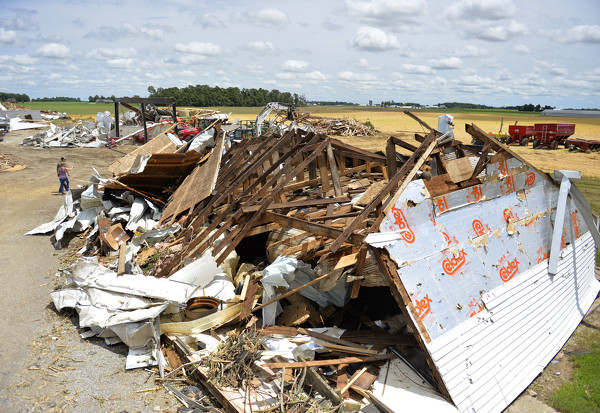
FORT RECOVERY - An EF2 tornado packing wind speeds up to 115 mph was confirmed near Fort Recovery on Friday afternoon, according to the National Weather Service in Wilmington.
No injuries were reported but the tornado, considered strong on the six [More]
Obituaries on June 21st, 2021
Major George W.  (Bill) Place, 87, of St. Marys died June 17, 2021 peacefully at home. [More]
Jerry W. "Eli" Ellis, age 69, of Mendon, passed away Saturday, June 19, 2021, at Celina Manor. [More]
Marvel Mae Stetler passed away June 18, 2021, at the Laurels of Shane Hill where she was a resident. [More]
Donald 'Don' R. Brown, age 90, of Wayne Lakes in Greenville (formerly of Celina [More]
Lauren Danielle Rupert, 29, Van Wert, died at 6:53 a.m. June 18, 2021, at Van Wert Health Emergency Room. [More]
Alice M. Hegemier, 87, of New Bremen, died on June 18, 2021 at Elmwood Assisted Living of New Bremen. [More]
Local pictures on June 21st, 2021
Subscriber stories on June 21st, 2021
Compiled by Tom Haines and Gary R. Rasberry
Kade Benavidez gave up two big hits at the tail end of a strong start and Grand Lake's offense couldn't recover, taking a 4-1 loss to Jet Box in Macomb on Sunday as the Mariners dropped a pair of weekend games.