Severe Thunderstorm Warning issued August 10 at 10:45PM EDT until August 10 at 11:00PM EDT by NWS Wilmington OH (details ...)
At 1045 PM EDT, a severe thunderstorm was located near Rockford, moving southeast at 35 mph. HAZARD...60 mph wind gusts. SOURCE...Radar indicated. IMPACT...Expect damage to trees and power lines. Locations impacted include... Celina, St. Marys, Rockford, Mendon, Montezuma, Neptune, Kossuth, State Route 116 at State Route 197, Bulkhead, and Tama.
Flood Advisory issued August 10 at 10:45PM EDT until August 11 at 1:45AM EDT by NWS Wilmington OH (details ...)
* WHAT...Flooding caused by excessive rainfall is expected. * WHERE...Northwestern Auglaize County in west central Ohio... Northern Mercer County in west central Ohio... * WHEN...Until 145 AM EDT. * IMPACTS...Minor flooding in low-lying and poor drainage areas. * ADDITIONAL DETAILS... - At 1045 PM EDT, radar indicated heavy rain due to thunderstorms. Minor flooding is ongoing or expected to begin shortly in the advisory area. Between 0.5 and 2 inches of rain have fallen. Additional rainfall amounts up to 2 inches are possible. - Some locations that may experience flooding include... Celina, St. Marys, Rockford, Moulton, Mendon, Buckland, Neptune, Tama, State Route 116 at State Route 197, Kossuth and Chattanooga.
Severe Thunderstorm Warning issued August 10 at 10:39PM EDT until August 10 at 11:15PM EDT by NWS Wilmington OH (details ...)
SVRILN The National Weather Service in Wilmington has issued a * Severe Thunderstorm Warning for... Northwestern Shelby County in west central Ohio... Auglaize County in west central Ohio... Southern Mercer County in west central Ohio... * Until 1115 PM EDT. * At 1039 PM EDT, a severe thunderstorm was located near St. Marys, moving southeast at 40 mph. HAZARD...60 mph wind gusts. SOURCE...Radar indicated. IMPACT...Expect damage to trees and power lines. * Locations impacted include... Sidney, Wapakoneta, St. Marys, Coldwater, New Bremen, Minster, Anna, Fort Loramie, Jackson Center, Botkins, New Knoxville, Hardin, Moulton, Chickasaw, Buckland, Kettlersville, Montezuma, Fryburg, Montra, and Newbern. This includes I-75 in Ohio between mile markers 96 and 115.
Severe Thunderstorm Watch issued August 10 at 7:26PM EDT until August 11 at 2:00AM EDT by NWS Wilmington OH (details ...)
THE NATIONAL WEATHER SERVICE HAS ISSUED SEVERE THUNDERSTORM WATCH 560 IN EFFECT UNTIL 2 AM EDT TUESDAY FOR THE FOLLOWING AREAS IN INDIANA THIS WATCH INCLUDES 1 COUNTY IN EAST CENTRAL INDIANA WAYNE IN OHIO THIS WATCH INCLUDES 21 COUNTIES IN CENTRAL OHIO DELAWARE FAIRFIELD FAYETTE FRANKLIN HOCKING LICKING MADISON PICKAWAY UNION IN WEST CENTRAL OHIO AUGLAIZE CHAMPAIGN CLARK DARKE GREENE HARDIN LOGAN MERCER MIAMI MONTGOMERY PREBLE SHELBY THIS INCLUDES THE CITIES OF ADA, BEAVERCREEK, BELLEFONTAINE, CAMDEN, CELINA, CIRCLEVILLE, COLDWATER, DELAWARE, DOWNTOWN COLUMBUS, DOWNTOWN DAYTON, EATON, FAIRBORN, GREENVILLE, KENTON, KETTERING, LANCASTER, LOGAN, LONDON, MARYSVILLE, MINSTER, NEW BREMEN, NEWARK, PICKERINGTON, PIQUA, PLAIN CITY, RICHMOND, SIDNEY, SPRINGFIELD, ST. MARYS, TIPP CITY, TROY, URBANA, WAPAKONETA, WASHINGTON COURT HOUSE, WEST JEFFERSON, AND XENIA.
Flood Watch issued August 10 at 1:04PM EDT until August 12 at 8:00AM EDT by NWS Wilmington OH (details ...)
* WHAT...Flash flooding caused by excessive rainfall is possible. * WHERE...Portions of Indiana, including the following counties, Dearborn, Fayette, Franklin, Union and Wayne, Kentucky, including the following counties, Boone, Bracken, Campbell, Kenton, Lewis, Mason, Pendleton and Robertson, and Ohio, including the following counties, Adams, Auglaize, Brown, Butler, Champaign, Clark, Clermont, Clinton, Darke, Delaware, Fairfield, Fayette, Franklin, Greene, Hamilton, Hardin, Highland, Hocking, Licking, Logan, Madison, Mercer, Miami, Montgomery, Pickaway, Pike, Preble, Ross, Scioto, Shelby, Union and Warren. * WHEN...Through Wednesday morning. * IMPACTS...Excessive runoff may result in flooding of rivers, creeks, streams, and other low-lying and flood-prone locations. * ADDITIONAL DETAILS... - Several rounds of thunderstorms are expected through Tuesday night. Locally heavy rainfall can be expected with the potential for storms to repeatedly track over the same locations. This will result in the potential for flash flooding.
Flash Flood Warning issued August 10 at 10:30PM EDT until August 11 at 1:30AM EDT by NWS Wilmington OH (details ...)
FFWILN The National Weather Service in Wilmington has issued a * Flash Flood Warning for... Northwestern Union County in central Ohio... Northeastern Auglaize County in west central Ohio... Southern Hardin County in west central Ohio... Logan County in west central Ohio... Northeastern Shelby County in west central Ohio... * Until 130 AM EDT. * At 1030 PM EDT, radar indicated thunderstorms producing heavy rain across the warned area. Between 1 and 2.5 inches of rain have fallen. Additional rainfall amounts up to 2.5 inches are possible. Flash flooding is ongoing or expected to begin shortly. HAZARD...Flash flooding caused by thunderstorms. SOURCE...Radar indicated. IMPACT...Flash flooding of small creeks and streams, urban areas, highways, streets and underpasses as well as other poor drainage and low-lying areas. * Some locations that may experience flash flooding include... Bellefontaine, Kenton, West Liberty, Russells Point, De Graff, Lakeview, Waynesfield, Belle Center, West Mansfield, Chippewa Park, Northwood, Roundhead, Quincy, Mount Victory, Rushsylvania, Huntsville, Ridgeway, Valley Hi, Zanesfield and Big Springs.
COLDWATER - Cases of COVID-19 in Mercer County have declined dramatically in the past few weeks, Mercer Health Community Hospital officials said during Wednesday's hospital board of governors meeting.
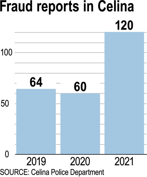
CELINA - Some Celina residents have exhausted their savings and/or cracked open their nest eggs in pursuit of romance, extraordinary prizes or other outcomes that wind up being scams, many of which originate from overseas. [More]
ST. MARYS - Quick action, by St. Marys City Schools superintendent and school resource officer kept a Thursday morning electrical fire in the middle school gym from possibly becoming more serious.
Rangers, Flyers advance to district final in Wapakoneta
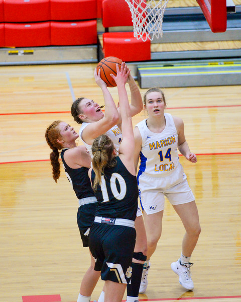
WAPAKONETA - Stout defenses propelled New Knoxville and Marion Local to district semifinal wins in Division IV girls basketball in Wapakoneta on Thursday.
Minster's Lucas Stammen and St. Marys' Griffin Luebke were the only area swimmers to earn spots in this evening's finals round of the Division II boys and girls state swimming championships at C.T. Branin Natatorium in Canton. [More]
St. Marys earned a spot in next week's Division II girls bowling state tournament after qualifying at the district tournament on Thursday at Interstate Lanes in Rossford.
St. Marys held off Bath down to the final buzzer to pick up a 36-34 victory in the Division II girls basketball district semifinal on Thursday night at Paulding High School.
CELINA - The Mercer County Council on Aging's senior center in recent years has placed an emphasis on offering a myriad physical activities to get folks moving.