Severe Thunderstorm Warning issued April 14 at 7:36PM EDT until April 14 at 8:30PM EDT by NWS Wilmington OH (details ...)
SVRILN The National Weather Service in Wilmington has issued a * Severe Thunderstorm Warning for... Shelby County in west central Ohio... Northwestern Champaign County in west central Ohio... Western Logan County in west central Ohio... Northeastern Darke County in west central Ohio... Southern Auglaize County in west central Ohio... Southeastern Mercer County in west central Ohio... * Until 830 PM EDT. * At 736 PM EDT, a severe thunderstorm was located near New Bremen, moving east at 40 mph. HAZARD...70 mph wind gusts and half dollar size hail. SOURCE...Radar indicated. IMPACT...Minor hail damage to vehicles is possible. Expect considerable tree damage. Wind damage is also likely to mobile homes, roofs, and outbuildings. * Locations impacted include... Sidney, Wapakoneta, St. Marys, New Bremen, Minster, Versailles, Newport, Anna, Fort Loramie, Jackson Center, Russells Point, De Graff, Botkins, Lakeview, New Knoxville, Chippewa Park, Moulton, Quincy, and Russia. This includes I-75 in Ohio between mile markers 86 and 111.
Severe Thunderstorm Watch issued April 14 at 7:35PM EDT until April 14 at 11:00PM EDT by NWS Wilmington OH (details ...)
SEVERE THUNDERSTORM WATCH 112 REMAINS VALID UNTIL 11 PM EDT THIS EVENING FOR THE FOLLOWING AREAS IN OHIO THIS WATCH INCLUDES 7 COUNTIES IN WEST CENTRAL OHIO AUGLAIZE DARKE MERCER MIAMI MONTGOMERY PREBLE SHELBY THIS INCLUDES THE CITIES OF CAMDEN, CELINA, COLDWATER, DOWNTOWN DAYTON, EATON, GREENVILLE, KETTERING, MINSTER, NEW BREMEN, PIQUA, SIDNEY, ST. MARYS, TIPP CITY, TROY, AND WAPAKONETA.
Severe Thunderstorm Warning issued April 14 at 7:33PM EDT until April 14 at 7:45PM EDT by NWS Wilmington OH (details ...)
At 733 PM EDT, a severe thunderstorm was located near St. Henry, moving east at 40 mph. HAZARD...70 mph wind gusts and half dollar size hail. SOURCE...Radar indicated. IMPACT...Minor hail damage to vehicles is possible. Expect considerable tree damage. Wind damage is also likely to mobile homes, roofs, and outbuildings. Locations impacted include... Celina, St. Marys, Coldwater, New Bremen, Minster, St. Henry, Chickasaw, Burkettsville, Montezuma, Egypt, Maria Stein, Carthagena, and Bulkhead.
Special Weather Statement issued April 14 at 7:26PM EDT by NWS Wilmington OH (details ...)
At 726 PM EDT, a strong thunderstorm was located near Wapakoneta, moving east at 40 mph. HAZARD...Wind gusts up to 40 mph and half inch hail. SOURCE...Radar indicated. IMPACT...Gusty winds could knock down tree limbs and blow around unsecured objects. Hail may cause minor damage to vegetation. Locations impacted include... Wapakoneta, Fort Shawnee, Cridersville, New Knoxville, Waynesfield, Moulton, Buckland, Uniopolis, Fryburg, Kossuth, New Hampshire, and St. Johns. This includes I-75 in Ohio between mile markers 106 and 118. If outdoors, consider seeking shelter inside a sturdy building. A Severe Thunderstorm Watch remains in effect until 1100 PM EDT for west central Ohio. To report hazardous weather conditions, go to our website at weather.gov/iln and submit your report via social media, when you can do so safely.
Friday, April 8th, 2022
Photo by Ryan Snyder/The Daily Standard
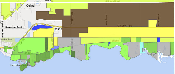
Various zoning classifications in East Jefferson Township. An interactive map of all county zoning is available at online.
CELINA - Now that all state requirements have been followed, Mercer County commissioners set a public hearing to consider regulating short-term rentals of properties in East Jefferson Township. [More]