Special Weather Statement issued May 1 at 12:13PM EDT by NWS Wilmington OH (details ...)
At 1212 PM EDT, a strong thunderstorm was located near New Bremen, moving northeast at 50 mph.
HAZARD...Wind gusts up to 45 mph and pea size hail.
SOURCE...Radar indicated.
IMPACT...Gusty winds could knock down tree limbs and blow around unsecured objects. Hail may cause minor damage to vegetation.
Locations impacted include... Newport, Fryburg, Montra, Egypt, Uniopolis, New Bremen, Buckland, Botkins, New Knoxville, Fort Loramie, Kettlersville, Moulton, Jackson Center, St. Marys, Anna, Kossuth, Lakeview, Lake Loramie State Park, Waynesfield, and Wapakoneta.
This includes I-75 in Ohio between mile markers 96 and 118.
If outdoors, consider seeking shelter inside a sturdy building.
To report hazardous weather conditions, go to our website at weather.gov/iln and submit your report via social media, when you can do so safely.
Today 74° Today 74° 58° 58° chance Tomorrow 71° Tomorrow 71° chance 54° 54° chance
Saturday, February 4th, 2023
Submitted Photo

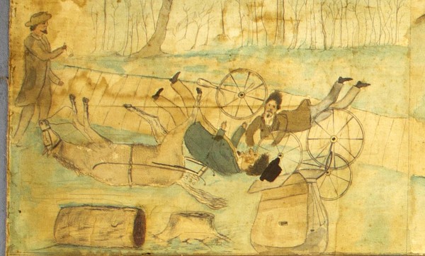
A wagon accident is depicted this painting of early St. Marys. The Auglaize County Historical Society is having the painting upgraded by a Cleveland conservator.

Related online story:
ST. MARYS - A folk art painting depicting a wagon accident in the early days of St. Marys is getting an upgrade.
The Auglaize County Historical Society is conserving the painting that was made some time after the Civil War. [More]
Additional pictures on this date