Severe Thunderstorm Watch issued April 27 at 11:27PM EDT until April 28 at 4:00AM EDT by NWS Wilmington OH (details ...)
SEVERE THUNDERSTORM WATCH 165 REMAINS VALID UNTIL 4 AM EDT TUESDAY FOR THE FOLLOWING AREAS
IN INDIANA THIS WATCH INCLUDES 8 COUNTIES
IN EAST CENTRAL INDIANA
FAYETTE UNION WAYNE
IN SOUTHEAST INDIANA
DEARBORN FRANKLIN OHIO RIPLEY SWITZERLAND
IN KENTUCKY THIS WATCH INCLUDES 10 COUNTIES
IN NORTHERN KENTUCKY
BOONE BRACKEN CAMPBELL CARROLL GALLATIN GRANT KENTON OWEN PENDLETON ROBERTSON
IN OHIO THIS WATCH INCLUDES 6 COUNTIES
IN SOUTHWEST OHIO
BUTLER CLERMONT HAMILTON
IN WEST CENTRAL OHIO
DARKE MERCER PREBLE
THIS INCLUDES THE CITIES OF ALEXANDRIA, AUGUSTA, AURORA, BATESVILLE, BELLEVUE, BRIGHT, BROOKSVILLE, BROOKVILLE, BURLINGTON, BUTLER, CAMDEN, CARROLLTON, CELINA, COLDWATER, CONNERSVILLE, COVINGTON, CRITTENDEN, DAY HEIGHTS, DAYTON, DILLSBORO, DOWNTOWN CINCINNATI, DRY RIDGE, EATON, ERLANGER, FAIRFIELD, FALMOUTH, FLORENCE, FORT THOMAS, GREENDALE, GREENVILLE, HAMILTON, HIDDEN VALLEY, HIGHLAND HEIGHTS, INDEPENDENCE, LAWRENCEBURG, LIBERTY, MIDDLETOWN, MILAN, MILFORD, MOUNT CARMEL, MOUNT OLIVET, MOUNT REPOSE, MULBERRY, NEWPORT, OAKBROOK, OSGOOD, OWENTON, OXFORD, RICHMOND, RISING SUN, SUMMERSIDE, VERSAILLES, VEVAY, WARSAW, WEST COLLEGE CORNER, WILLIAMSTOWN, AND WITHAMSVILLE.
Special Weather Statement issued April 27 at 11:00PM EDT by NWS Wilmington OH (details ...)
Wind gusts of 35 to 50 MPH will be possible over the next few hours. These winds will occur separately from any thunderstorms. Winds of this magnitude may damage small tree limbs and make driving difficult, especially for high profile vehicles.
Severe Thunderstorm Warning issued April 28 at 12:25AM EDT until April 28 at 1:00AM EDT by NWS Wilmington OH (details ...)
At 1225 AM EDT, severe thunderstorms were located along a line extending from near Newport to near Eaton, moving northeast at 70 mph.
HAZARD...60 mph wind gusts.
SOURCE...Radar indicated.
IMPACT...Expect damage to trees and power lines.
Locations impacted include... Trotwood, Piqua, Englewood, Greenville, Eaton, West Milton, New Bremen, Minster, Versailles, Covington, Arcanum, Newport, Bradford, Lewisburg, New Paris, Fort Loramie, West Alexandria, Pleasant Hill, New Madison, and New Knoxville.
This includes I-70 in Ohio between mile markers 1 and 26.
Severe Thunderstorm Watch issued April 27 at 11:27PM EDT until April 28 at 4:00AM EDT by NWS Wilmington OH (details ...)
THE NATIONAL WEATHER SERVICE HAS EXTENDED SEVERE THUNDERSTORM WATCH 165 TO INCLUDE THE FOLLOWING AREAS UNTIL 4 AM EDT TUESDAY
IN OHIO THIS WATCH INCLUDES 5 COUNTIES
IN SOUTHWEST OHIO
WARREN
IN WEST CENTRAL OHIO
AUGLAIZE MIAMI MONTGOMERY SHELBY
THIS INCLUDES THE CITIES OF DOWNTOWN DAYTON, FRANKLIN, KETTERING, LANDEN, LEBANON, MASON, MINSTER, NEW BREMEN, PIQUA, SIDNEY, SPRINGBORO, ST. MARYS, TIPP CITY, TROY, AND WAPAKONETA.
61° 61° Tue 72° Tue 72° chance 50° 50° likely Wed 60° Wed 60° likely
Monday, June 19th, 2023
Obituaries on June 19th, 2023
Eileen E. Pleiman, age 94 of Osgood, Ohio, died Friday, June 16, 2023, at Briarwood Village in Coldwater. [More]
Mary Ann Severt, 94, died June 14, 2023 in Port Royal, Pa at the home of her da [More]
Barbara Delzeith, age 71 of Coldwater, passed away on Saturday, June 17, 2023, at the Ohio State Medical Center in Columbus. [More]
Stories on June 19th, 2023
Deal would have meant jobs, revenue
The Ohio Power Sitting Board recently denied applications for a rehearing on the Birch Solar project, a proposed 300 megawatt solar farm in Allen and Auglaize counties.
Softball Dream Team
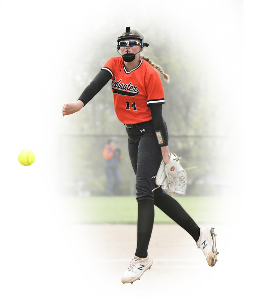
When she is on her game - and more often than not, that is the case - Madison Wendel dominates the game of softball in this area.
The Coldwater junior repeats as The Daily Standard's Softball Dream Team Player of the Year after another stellar season in the pitching circle and at the plate. [More]
Weekend Roundup
Compiled by Gary R. Rasberry
Anthony Zarlingo's fly ball to right in the tiebreaker 11th inning scored Eduarny Martinez to give Lima a 3-2 victor
Local pictures on June 19th, 2023