Severe Thunderstorm Watch issued May 19 at 4:39PM EDT until May 19 at 10:00PM EDT by NWS Wilmington OH (details ...)
THE NATIONAL WEATHER SERVICE HAS ISSUED SEVERE THUNDERSTORM WATCH 231 IN EFFECT UNTIL 10 PM EDT THIS EVENING FOR THE FOLLOWING AREAS
IN INDIANA THIS WATCH INCLUDES 6 COUNTIES
IN EAST CENTRAL INDIANA
FAYETTE UNION WAYNE
IN SOUTHEAST INDIANA
DEARBORN FRANKLIN RIPLEY
IN OHIO THIS WATCH INCLUDES 16 COUNTIES
IN CENTRAL OHIO
UNION
IN SOUTHWEST OHIO
BUTLER HAMILTON WARREN
IN WEST CENTRAL OHIO
AUGLAIZE CHAMPAIGN CLARK DARKE GREENE HARDIN LOGAN MERCER MIAMI MONTGOMERY PREBLE SHELBY
THIS INCLUDES THE CITIES OF ADA, AURORA, BATESVILLE, BEAVERCREEK, BELLEFONTAINE, BRIGHT, BROOKVILLE, CAMDEN, CELINA, COLDWATER, CONNERSVILLE, DILLSBORO, DOWNTOWN CINCINNATI, DOWNTOWN DAYTON, EATON, FAIRBORN, FAIRFIELD, FRANKLIN, GREENDALE, GREENVILLE, HAMILTON, HIDDEN VALLEY, KENTON, KETTERING, LANDEN, LAWRENCEBURG, LEBANON, LIBERTY, MARYSVILLE, MASON, MIDDLETOWN, MILAN, MINSTER, NEW BREMEN, OSGOOD, OXFORD, PIQUA, RICHMOND, SIDNEY, SPRINGBORO, SPRINGFIELD, ST. MARYS, TIPP CITY, TROY, URBANA, VERSAILLES, WAPAKONETA, WEST COLLEGE CORNER, AND XENIA.
Special Weather Statement issued May 19 at 6:06PM EDT by NWS Wilmington OH (details ...)
At 605 PM EDT, a strong thunderstorm was located over New Knoxville, moving northeast at 35 mph.
HAZARD...Wind gusts up to 45 mph and half inch hail.
SOURCE...Radar indicated.
IMPACT...Gusty winds could knock down tree limbs and blow around unsecured objects. Hail may cause minor damage to vegetation.
Locations impacted include... Wapakoneta, St. Marys, Fort Shawnee, New Bremen, Minster, Cridersville, Botkins, New Knoxville, Waynesfield, Moulton, Buckland, Uniopolis, Kettlersville, Fryburg, Lake Loramie State Park, St. Johns, and Bulkhead.
This includes I-75 in Ohio between mile markers 104 and 118.
If outdoors, consider seeking shelter inside a sturdy building.
A Severe Thunderstorm Watch remains in effect until 1000 PM EDT for west central Ohio.
To report hazardous weather conditions, go to our website at weather.gov/iln and submit your report via social media, when you can do so safely.
Today 88° Today 88° slight chance chance 60° 60° likely Tomorrow 68° Tomorrow 68° chance 47° 47°
Thursday, February 8th, 2024
Multiple injury accidents
Photo by Aaron Snyder/The Daily Standard

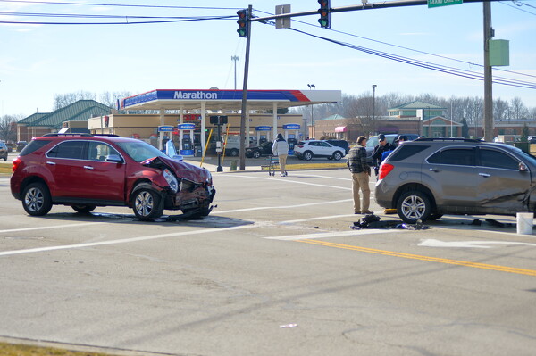
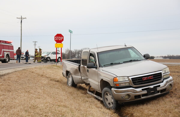
At least one person was injured in a three-vehicle accident at the intersection of East Wayne Street and Grand Lake Road on Wednesday morning. At 11:09 a.m., Celina police responded to an injury accident. A vehicle ran a red light and hit an oncoming vehicle. Another vehicle that was stopped at the light was also struck. One person with minor injuries was reportedly taken to the hospital via squad. Drugs and alcohol aren't suspected, although police will issue a red light violation to the offending driver. No other information was available by press time.

Additional pictures on this date