Severe Thunderstorm Watch issued May 19 at 4:39PM EDT until May 19 at 10:00PM EDT by NWS Wilmington OH (details ...)
THE NATIONAL WEATHER SERVICE HAS ISSUED SEVERE THUNDERSTORM WATCH 231 IN EFFECT UNTIL 10 PM EDT THIS EVENING FOR THE FOLLOWING AREAS
IN INDIANA THIS WATCH INCLUDES 6 COUNTIES
IN EAST CENTRAL INDIANA
FAYETTE UNION WAYNE
IN SOUTHEAST INDIANA
DEARBORN FRANKLIN RIPLEY
IN OHIO THIS WATCH INCLUDES 16 COUNTIES
IN CENTRAL OHIO
UNION
IN SOUTHWEST OHIO
BUTLER HAMILTON WARREN
IN WEST CENTRAL OHIO
AUGLAIZE CHAMPAIGN CLARK DARKE GREENE HARDIN LOGAN MERCER MIAMI MONTGOMERY PREBLE SHELBY
THIS INCLUDES THE CITIES OF ADA, AURORA, BATESVILLE, BEAVERCREEK, BELLEFONTAINE, BRIGHT, BROOKVILLE, CAMDEN, CELINA, COLDWATER, CONNERSVILLE, DILLSBORO, DOWNTOWN CINCINNATI, DOWNTOWN DAYTON, EATON, FAIRBORN, FAIRFIELD, FRANKLIN, GREENDALE, GREENVILLE, HAMILTON, HIDDEN VALLEY, KENTON, KETTERING, LANDEN, LAWRENCEBURG, LEBANON, LIBERTY, MARYSVILLE, MASON, MIDDLETOWN, MILAN, MINSTER, NEW BREMEN, OSGOOD, OXFORD, PIQUA, RICHMOND, SIDNEY, SPRINGBORO, SPRINGFIELD, ST. MARYS, TIPP CITY, TROY, URBANA, VERSAILLES, WAPAKONETA, WEST COLLEGE CORNER, AND XENIA.
Special Weather Statement issued May 19 at 6:40PM EDT by NWS Wilmington OH (details ...)
At 640 PM EDT, strong thunderstorms were located along a line extending from near Ada to Jackson Center, moving northeast at 50 mph.
HAZARD...Wind gusts up to 45 mph, pea size hail, and very heavy rain.
SOURCE...Radar indicated.
IMPACT...Gusty winds could knock down tree limbs and blow around unsecured objects. Hail may cause minor damage to vegetation. Visibility will be poor and hydroplaning is possible.
Locations impacted include... Sidney, Bellefontaine, Kenton, Ada, Jackson Center, Forest, Russells Point, De Graff, Lakeview, Dunkirk, Alger, Waynesfield, Belle Center, West Mansfield, Chippewa Park, Northwood, Blanchard, Roundhead, Quincy, and Mount Victory.
This includes I-75 in Ohio between mile markers 92 and 98.
If outdoors, consider seeking shelter inside a sturdy building.
Motorists should slow down and use extra caution.
A Severe Thunderstorm Watch remains in effect until 1000 PM EDT for central and west central Ohio.
To report hazardous weather conditions, go to our website at weather.gov/iln and submit your report via social media, when you can do so safely.
Today 88° Today 88° slight chance chance 60° 60° likely Tomorrow 68° Tomorrow 68° chance 47° 47°
Friday, February 9th, 2024
Photo from Associated Press

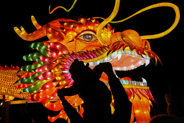
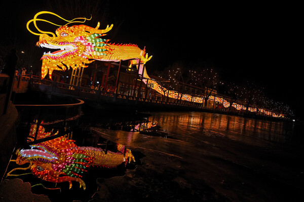
A man and a toddler are silhouetted as they pose for a souvenir photo with a giant dragon lantern decorated near the popular Houhai Lake in Beijing, Thursday, Feb. 8, 2024. Chinese will celebrate Lunar New Year on Feb. 10 this year which marks the Year of the dragon on the Chinese zodiac. (AP Photo/Andy Wong)

Related online story:
CELINA - The holiday season isn't over yet.
Saturday is Lunar New Year, an occasion for people to bring their entire family together and set good intentions for the next 12 months. [More]
Additional pictures on this date