Severe Thunderstorm Warning issued July 3 at 6:15PM EDT until July 3 at 7:00PM EDT by NWS Wilmington OH (details ...)
SVRILN
The National Weather Service in Wilmington has issued a
* Severe Thunderstorm Warning for... Northern Darke County in west central Ohio... Southern Mercer County in west central Ohio...
* Until 700 PM EDT.
* At 614 PM EDT, a severe thunderstorm was located near Portland, moving east at 30 mph.
HAZARD...60 mph wind gusts.
SOURCE...Radar indicated.
IMPACT...Expect damage to trees and power lines.
* Locations impacted include... Celina, Coldwater, St. Henry, Fort Recovery, Wabash, Osgood, Burkettsville, North Star, Rossburg, Montezuma, New Weston, Yorkshire, Cosmos, Brock, Eldora Speedway, and Carthagena.
Extreme Heat Warning issued July 3 at 11:21AM EDT until July 3 at 8:00PM EDT by NWS Wilmington OH (details ...)
* WHAT...For the Extreme Heat Warning, dangerously hot conditions with heat index values around 105 are expected. For the Heat Advisory, heat index values around 100 are expected.
* WHERE...Portions of east central and southeast Indiana, northeast and northern Kentucky, and central, south central, southwest, and west central Ohio.
* WHEN...For the Extreme Heat Warning, until 8 PM EDT this evening. For the Heat Advisory, from 8 PM this evening to 8 PM EDT Saturday.
* IMPACTS...Heat related illnesses increase significantly during extreme heat and high humidity events, particularly for those working or participating in outdoor activities. Hot temperatures and high humidity may cause heat illnesses.
* ADDITIONAL DETAILS...Remember, multiple days with excessive heat can have compounding effects.
Heat Advisory issued July 3 at 11:21AM EDT until July 4 at 8:00PM EDT by NWS Wilmington OH (details ...)
* WHAT...For the Extreme Heat Warning, dangerously hot conditions with heat index values around 105 are expected. For the Heat Advisory, heat index values around 100 are expected.
* WHERE...Portions of east central and southeast Indiana, northeast and northern Kentucky, and central, south central, southwest, and west central Ohio.
* WHEN...For the Extreme Heat Warning, until 8 PM EDT this evening. For the Heat Advisory, from 8 PM this evening to 8 PM EDT Saturday.
* IMPACTS...Heat related illnesses increase significantly during extreme heat and high humidity events, particularly for those working or participating in outdoor activities. Hot temperatures and high humidity may cause heat illnesses.
* ADDITIONAL DETAILS...Remember, multiple days with excessive heat can have compounding effects.
Today 93° Today 93° slight chance 75° 75° chance Tomorrow 90° Tomorrow 90° slight chance 72° 72° chance likely
Tuesday, February 13th, 2024
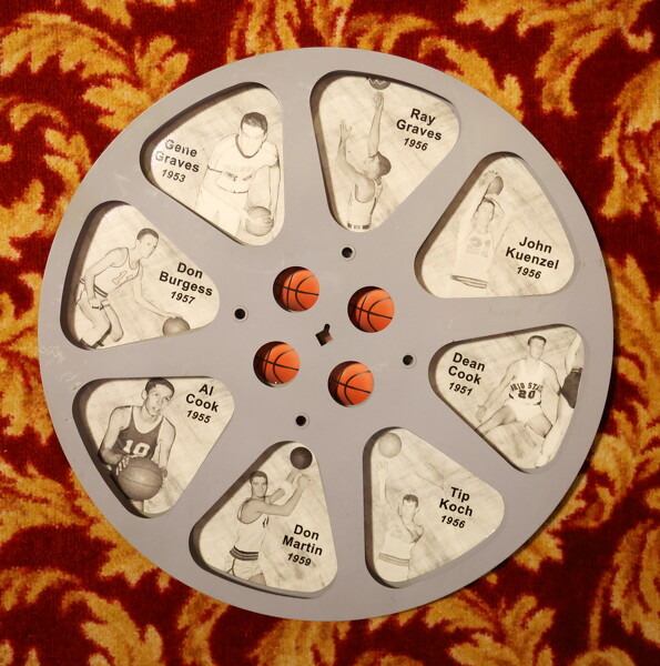
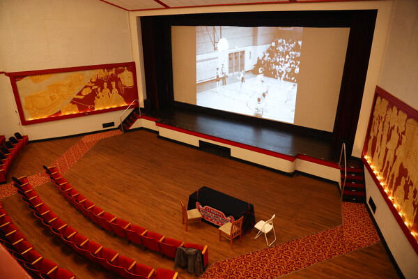
Photo by Paige Sutter/The Daily Standard

A 16 mm film reel featuring some of St. Marys's standout players of the 1950s.

Related online story:
ST. MARYS - Fans of the Grand Lake Rivalry will get a chance to see their teams face off from 70 years ago next week.  
The St. Marys Theatre/Gra [More]
Additional pictures on this date