The Daily Standard
Story Archive

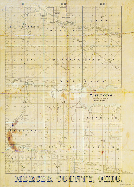
Map of Mercer County from 1852 by Willshire Riley. Our online historical map viewer is here.
By the virtues of luck and timing, a 172 year old map of Mercer County is now digitized.
The Mercer County 1852 map is signed by Willshire Riley and was in the possession of Art Bruns in 1957 when he showed it to Bronsart Gilberg. Bruns came into possession of the map when a real estate agent prepared a residence for sale in the mid 20th century. When he found the map, it was folded and wet and to preserve it, he lacquered it to a board.
The map expanded upon the 1819 Ohio Land Survey of Mercer County, which was completed by Willshire Riley's father, the former ship captain, James Riley. Willshire's map added roads, settlements, streams and the outline of the Reservoir, which had initially appeared as a swamp on the land survey. The Reservoir is known now as Grand Lake.
Comparing the current countryside to the map from 1852 shows many additions, some subtractions and a few unusual changes.
The map from 1852 does not show Coldwater, St. Anthony/Padua, Chattanooga, Cassella, Burkettsville, St. Sebastian, Erastus, Durbin and other current locations for varying reasons. Coldwater was not platted until 1859, thus not existing in 1852 like many of the others. St. Anthony/Padua and Chattanooga remain not platted.
Two settlements appear on the 1852 map that no longer exist today. At the corner of the present roads of Philothea and State Route 118 was the former town of Monterey, which is still platted but only contains a few houses now.
Montpelier appears on the historic map at the current intersections of U.S. 127, State Route 703 and Green Road. It is said to have been an early settlement of French pioneers who established their homes at the southwest corner of the Reservoir.
One theory is that the founders of Montpelier were employed on the Reservoir construction work and after its completion, established the village which they named after Montpelier, a city in southern France, presumably near their native homes.
Some township lines even seem to move from their current location, an anomaly due to the 1852 map showing the survey townships and ranges as opposed to the current governmental townships by which officials today subdivide the county.
Wabash, plagued by spring flooding at the confluence of the Wabash River and what was then labeled Big Beaver River, moved its community to higher ground southwest of its former location.
Just as many villages and towns have been added in the subsequent 172 years, roads have proliferated.
The historic trail titled St. Marys and Willshire Plank Road is the predecessor to U.S. 33, slicing a diagonal through what is labeled Shanesville, Mercer and Neptune. This was Mercer County's first attempt to lift its pioneer traffic out of the wheel-breaking ruts and the gripping, gummy mud. Shanesville is now Rockford.
People cut down trees and split them along the route, laying them side-by-side across the road, assuring a solid but rough ride.
Roads today are smoother and straighter than their historic courses. The historic map details two parallel roads, one on either side of the Wabash River heading north of Fort Recovery, neither of which exist today.
Likewise, there was once a road from Mercer to Mendon. Subsequently the Hamilton Dayton Rail Road followed this path. Today, only a few trees are still cut at this angle, hinting at the historic line.
The sparsity of the map is akin to the realities of the time. According to 1850 Census data, Mercer County was home to 7,712 people. 1,428 of these people resided in Marion Township and 273 were listed as "free colored people."
In 2020, there were 42,528 residents in the county, per 2020 Census data.
About 74% of the population at the time lived in the north and south portions of the county.
Dublin Township records the second highest population at 914, followed by Union Township, 746; Recovery, 596; Granville, 564; Centre (now Center), 491; Black Creek, 490; and Gibson, 485.
Jefferson Township, by contrast, contained only 271 people with an additional 222 total residents in Celina.
Although not shown on the map, Mercer County contained 65 public schools with 1,335 pupils in 1850. By comparison, 19,654 livestock animals were counted.
- Originally ran Jan. 2, 1957
Horse and Buggy Tales originally written by Bronsart H. Gilberg are being reprinted in The Daily Standard on a weekly basis. The column ran from 1956 to the mid 1970s.