Flood Advisory issued August 10 at 10:45PM EDT until August 11 at 1:45AM EDT by NWS Wilmington OH (details ...)
* WHAT...Flooding caused by excessive rainfall is expected.
* WHERE...Northwestern Auglaize County in west central Ohio... Northern Mercer County in west central Ohio...
* WHEN...Until 145 AM EDT.
* IMPACTS...Minor flooding in low-lying and poor drainage areas.
* ADDITIONAL DETAILS... - At 1045 PM EDT, radar indicated heavy rain due to thunderstorms. Minor flooding is ongoing or expected to begin shortly in the advisory area. Between 0.5 and 2 inches of rain have fallen. Additional rainfall amounts up to 2 inches are possible. - Some locations that may experience flooding include... Celina, St. Marys, Rockford, Moulton, Mendon, Buckland, Neptune, Tama, State Route 116 at State Route 197, Kossuth and Chattanooga.
Severe Thunderstorm Watch issued August 10 at 7:26PM EDT until August 11 at 2:00AM EDT by NWS Wilmington OH (details ...)
THE NATIONAL WEATHER SERVICE HAS ISSUED SEVERE THUNDERSTORM WATCH 560 IN EFFECT UNTIL 2 AM EDT TUESDAY FOR THE FOLLOWING AREAS
IN INDIANA THIS WATCH INCLUDES 1 COUNTY
IN EAST CENTRAL INDIANA
WAYNE
IN OHIO THIS WATCH INCLUDES 21 COUNTIES
IN CENTRAL OHIO
DELAWARE FAIRFIELD FAYETTE FRANKLIN HOCKING LICKING MADISON PICKAWAY UNION
IN WEST CENTRAL OHIO
AUGLAIZE CHAMPAIGN CLARK DARKE GREENE HARDIN LOGAN MERCER MIAMI MONTGOMERY PREBLE SHELBY
THIS INCLUDES THE CITIES OF ADA, BEAVERCREEK, BELLEFONTAINE, CAMDEN, CELINA, CIRCLEVILLE, COLDWATER, DELAWARE, DOWNTOWN COLUMBUS, DOWNTOWN DAYTON, EATON, FAIRBORN, GREENVILLE, KENTON, KETTERING, LANCASTER, LOGAN, LONDON, MARYSVILLE, MINSTER, NEW BREMEN, NEWARK, PICKERINGTON, PIQUA, PLAIN CITY, RICHMOND, SIDNEY, SPRINGFIELD, ST. MARYS, TIPP CITY, TROY, URBANA, WAPAKONETA, WASHINGTON COURT HOUSE, WEST JEFFERSON, AND XENIA.
Flood Watch issued August 10 at 1:04PM EDT until August 12 at 8:00AM EDT by NWS Wilmington OH (details ...)
* WHAT...Flash flooding caused by excessive rainfall is possible.
* WHERE...Portions of Indiana, including the following counties, Dearborn, Fayette, Franklin, Union and Wayne, Kentucky, including the following counties, Boone, Bracken, Campbell, Kenton, Lewis, Mason, Pendleton and Robertson, and Ohio, including the following counties, Adams, Auglaize, Brown, Butler, Champaign, Clark, Clermont, Clinton, Darke, Delaware, Fairfield, Fayette, Franklin, Greene, Hamilton, Hardin, Highland, Hocking, Licking, Logan, Madison, Mercer, Miami, Montgomery, Pickaway, Pike, Preble, Ross, Scioto, Shelby, Union and Warren.
* WHEN...Through Wednesday morning.
* IMPACTS...Excessive runoff may result in flooding of rivers, creeks, streams, and other low-lying and flood-prone locations.
* ADDITIONAL DETAILS... - Several rounds of thunderstorms are expected through Tuesday night. Locally heavy rainfall can be expected with the potential for storms to repeatedly track over the same locations. This will result in the potential for flash flooding.
Flash Flood Warning issued August 10 at 11:11PM EDT until August 11 at 1:30AM EDT by NWS Wilmington OH (details ...)
At 1111 PM EDT, radar indicated thunderstorms producing heavy rain across the warned area. Between 2 and 4 inches of rain have fallen. Additional rainfall amounts up to 1 inch are possible. Flash flooding is ongoing or expected to begin shortly.
HAZARD...Flash flooding caused by thunderstorms.
SOURCE...Radar indicated.
IMPACT...Flash flooding of small creeks and streams, urban areas, highways, streets and underpasses as well as other poor drainage and low-lying areas.
Some locations that may experience flash flooding include... Bellefontaine, Kenton, West Liberty, Russells Point, De Graff, Lakeview, Waynesfield, Belle Center, West Mansfield, Chippewa Park, Northwood, Roundhead, Quincy, Mount Victory, Rushsylvania, Huntsville, Ridgeway, Valley Hi, Zanesfield and Big Springs.
69° 69° chance Tue 82° Tue 82° likely 66° 66° likely Wed 82° Wed 82° chance
Wednesday, August 30th, 2006

Twin tornadoes blamed for local damage

By Shelley Grieshop
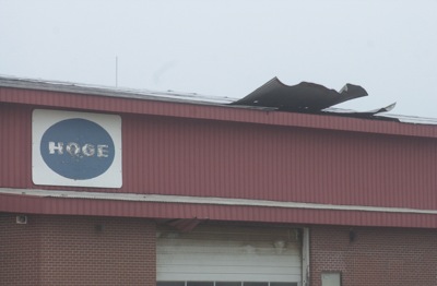
Photo by Mark Pummell/The Daily Standard

Damage is visible to the roof of one of the buildings at Hoge Lumber Co. in New Knoxville, near the spot where a confirmed tornado touched down Monday evening. Fifteen homes also sustained damage from the F0 tornado, the weakest designation for tornadoes given by the National Weather Service.

A pair of weak tornadoes were officially confirmed as causing damage Monday evening to 15 homes and at least one business in New Knoxville and a home and crops near St. Henry.
The National Weather Service (NWS) said F0 tornadoes, the weakest on the scale used to rate destructiveness, spawned off a slow-moving storm and touched down in both regions but caused no injuries. Winds associated with an F0 tornado reach speeds of 40 to 72 mph, according to NWS officials who surveyed both areas on Tuesday afternoon.
No dollar amounts have been set on damages in either county, according to area Emergency Management Agency (EMA) directors.
Mercer County EMA Director Wanda Dicke said a cornfield two to three miles southwest of St. Henry along Fort Recovery-Minster Road looked like it was plowed down by rolling equipment. Corn cobs from the field were ripped from husks and landed on the nearby roof of Fred and Irene Rose's home, which sustained moderate damage.
"That corn is still green so it had to be a very powerful wind to remove it from the husks," said Dicke.
Irene Rose told Dicke the corn found on their roof was so mutilated, she referred to it as "creamed corn." Rose also noted the sound of the wind led the couple to believe the entire roof was going to blow away.
The Mercer County tornado made its way through two corn fields and a bean field before quickly lifting from the ground just after 9:20 p.m., officials said. The path was estimated at 60 yards wide and3/4 to one mile long, the NWS reported.
In Auglaize County, an F0 tornado touched down about 10 p.m. near the intersection of state Route 29 and Hoge Street on the southern edge of New Knoxville, lifting small buildings off their foundation, knocking down trees and ripping away siding and shingles from more than a dozen homes.
Buildings on the lot of Hoge Lumber Co. sustained minor damages, also.
The NWS did not issue a tornado warning for Auglaize County as they did for Mercer County. Auglaize County EMA Director Troy Anderson and other Auglaize County officials are looking into the reason why the county continues to be overlooked by the NWS when threatening weather is imminent.
Anderson said he did not activate sirens in any of the communities but instead issued a weather statement to fire and police departments in New Bremen, Minster and New Knoxville, about 10 minutes before the storm approached. Anderson said he based his actions on the heavy rain and wind, tornadic conditions and the warning issued 30 minutes earlier in Mercer County.
Anderson said the NWS gave Auglaize County an "all clear" from the storm at 9:50 p.m. - 10 minutes before the tornado touched down in New Knoxville, he said.
The small tornado was on the ground for about3/4 of a mile and was 300 yards wide at its greatest width, the NWS said. Anderson said the brunt of the damage was noted to properties near the Hoge Street intersection where the tornado initially touched down.
"Some homes had damage from flying debris, others lost siding and shingles," he said.

Additional online stories on this date
Members of the Animal Protection League are unhappy with the outcome of their private meeting Tuesday with Mercer County Commissioner Bob Nuding about conditions at the county dog pound. [More]
It was the first game of the season for the Celina volleyball team and it looked like the first game of the season for the Bulldogs.
St. Henry, pla [More]
Subscriber and paid stories on this date
MENDON - Some village officials believe there is a growing problem of illegal open burning in town while others noted a fine line between lawful fires and those that violate state and local laws.
WAPAKONETA - Several area residents have appeared in court recently following a drug bust Aug. 18 by area law enforcement and the Grand Lake Drug Task Force.
MENDON - The village will spray one time for mosquitoes through River Trail Campground but the owner will have to pay for any further service.
Vill
Coldwater Village Council is looking at a method to remove sludge buildup in pond two at the water treatment plant, councilors learned Monday.
Village Manager Engineer Eric Thomas described the operation of a geotube that could be used to collect the sludge and drain the water.
WAPAKONETA - Auglaize County election board members unanimously approved a rental agreement with Triad GSI to supply election software and service.
MARIA STEIN - Okay, so it's just one win and it's a win in the first of a 22-match schedule, but Marion Local's 26-24, 25-16, 21-25, 25-21 win over the Lehman Catholic Cavaliers on Tuesday night at the Hangar was indeed special for Flyer coach Amy Steininger and her charges.
Celina opened Western Buckeye League girls soccer play in style, edging rival St. Marys, 2-1, at a soggy Celina Soccer Stadium on Tuesday night.
Th
Compiled by Gary R. Rasberry
The St. Henry boys picked up a big win on the cross country season as they captured the Mercer County Invitational title on Tuesday at Coldwater.
NEW KNOXVILLE - To the casual observer, the New Knoxville Lady Rangers looked in mid- to late-season form last evening as they dominated the St. Marys Roughriders at home in three games by finals of 25-10, 25-9, and 25-11.