Severe Thunderstorm Warning issued March 26 at 8:27PM EDT until March 26 at 9:15PM EDT by NWS Wilmington OH (details ...)
SVRILN
The National Weather Service in Wilmington has issued a
* Severe Thunderstorm Warning for... Shelby County in west central Ohio... Southwestern Logan County in west central Ohio... Northeastern Darke County in west central Ohio... Southwestern Auglaize County in west central Ohio... Southeastern Mercer County in west central Ohio...
* Until 915 PM EDT.
* At 827 PM EDT, a severe thunderstorm was located over New Bremen, moving east at 45 mph.
HAZARD...Golf ball size hail and 60 mph wind gusts.
SOURCE...Radar indicated.
IMPACT...People and animals outdoors will be injured. Expect hail damage to roofs, siding, windows, and vehicles. Expect wind damage to trees and power lines.
* Locations impacted include... Sidney, New Bremen, Minster, Newport, Anna, Fort Loramie, Jackson Center, De Graff, Botkins, New Knoxville, Hardin, Quincy, Russia, Port Jefferson, Osgood, Kettlersville, Lockington, Yorkshire, Montra, and Newbern.
Tornado Watch issued March 26 at 7:37PM EDT until March 26 at 11:00PM EDT by NWS Wilmington OH (details ...)
TORNADO WATCH 75 REMAINS VALID UNTIL 11 PM EDT THIS EVENING FOR THE FOLLOWING AREAS
IN OHIO THIS WATCH INCLUDES 8 COUNTIES
IN CENTRAL OHIO
DELAWARE LICKING UNION OH
IN WEST CENTRAL OHIO
AUGLAIZE HARDIN LOGAN MERCER SHELBY
THIS INCLUDES THE CITIES OF ADA, BELLEFONTAINE, CELINA, COLDWATER, DELAWARE, KENTON, MARYSVILLE, NEWARK, SIDNEY, ST. MARYS, AND WAPAKONETA.
35° 35° Fri 45° Fri 45° 27° 27° Sat 47° Sat 47°
Tuesday, October 3rd, 2006
Howling good time
Photo by Mark Pummell/The Daily Standard

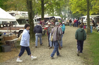
Traders Days, a weekend where residents trade treasurers at the Ohio Progressive Sportsman Club near Sharpsburg, was a busy place Saturday. Stands were sold out the week before and sellers came from more than four hours away.

Additional pictures on this date