Special Weather Statement issued May 1 at 12:13PM EDT by NWS Wilmington OH (details ...)
At 1212 PM EDT, a strong thunderstorm was located near New Bremen, moving northeast at 50 mph.
HAZARD...Wind gusts up to 45 mph and pea size hail.
SOURCE...Radar indicated.
IMPACT...Gusty winds could knock down tree limbs and blow around unsecured objects. Hail may cause minor damage to vegetation.
Locations impacted include... Newport, Fryburg, Montra, Egypt, Uniopolis, New Bremen, Buckland, Botkins, New Knoxville, Fort Loramie, Kettlersville, Moulton, Jackson Center, St. Marys, Anna, Kossuth, Lakeview, Lake Loramie State Park, Waynesfield, and Wapakoneta.
This includes I-75 in Ohio between mile markers 96 and 118.
If outdoors, consider seeking shelter inside a sturdy building.
To report hazardous weather conditions, go to our website at weather.gov/iln and submit your report via social media, when you can do so safely.
Today 74° Today 74° 58° 58° chance Tomorrow 71° Tomorrow 71° chance 54° 54° chance
Saturday, February 3rd, 2007
Photo by Mark Pummell/The Daily Standard

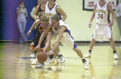
Coldwater's Cory Klenke, left, and Marion Local's Chris Stucke, right, chase after a loose ball during their Midwest Athletic Conference contest on Friday night at The Hangar. Coldwater won the battle of Mercer County schools, 49-42.

Related online story:
MARIA STEIN - The Coldwater Cavaliers certainly didn't start fast Friday night at the Hangar, but they scored in a flurry when they needed to in pinning a 49-42 loss on the Marion Local Flyers. [More]
Additional pictures on this date