Special Weather Statement issued May 1 at 12:13PM EDT by NWS Wilmington OH (details ...)
At 1212 PM EDT, a strong thunderstorm was located near New Bremen, moving northeast at 50 mph.
HAZARD...Wind gusts up to 45 mph and pea size hail.
SOURCE...Radar indicated.
IMPACT...Gusty winds could knock down tree limbs and blow around unsecured objects. Hail may cause minor damage to vegetation.
Locations impacted include... Newport, Fryburg, Montra, Egypt, Uniopolis, New Bremen, Buckland, Botkins, New Knoxville, Fort Loramie, Kettlersville, Moulton, Jackson Center, St. Marys, Anna, Kossuth, Lakeview, Lake Loramie State Park, Waynesfield, and Wapakoneta.
This includes I-75 in Ohio between mile markers 96 and 118.
If outdoors, consider seeking shelter inside a sturdy building.
To report hazardous weather conditions, go to our website at weather.gov/iln and submit your report via social media, when you can do so safely.
Today 74° Today 74° 58° 58° chance Tomorrow 71° Tomorrow 71° chance 54° 54° chance
Wednesday, February 7th, 2007
Photo by Shelley Grieshop/The Daily Standard

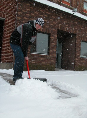
At left, employee Greg Schweizer shovels a large pile of snow from in front of the Celina Music Store on Tuesday afternoon. More than 3 inches of snow fell across the Grand Lake area, causing roadways to become slippery and hazardous. No new snow accumulations are in the forecast for the rest of the week and temperatures are expected to rise, a little, with highs in the upper teens for today and a high of 18 on Thursday, according to local weather forecaster Dennis Howick.

Related online story:
A winter blast dropped more than 3 inches of snow on the Grand Lake area, causing the cancellation of classes at all schools in Mercer and Auglaize counties today. [More]
Additional pictures on this date