Severe Thunderstorm Watch issued September 5 at 2:36AM EDT until September 5 at 8:00AM EDT by NWS Wilmington OH (details ...)
THE NATIONAL WEATHER SERVICE HAS ISSUED SEVERE THUNDERSTORM WATCH 655 IN EFFECT UNTIL 8 AM EDT THIS MORNING FOR THE FOLLOWING AREAS
IN OHIO THIS WATCH INCLUDES 11 COUNTIES
IN CENTRAL OHIO
DELAWARE FAIRFIELD FRANKLIN LICKING UNION
IN WEST CENTRAL OHIO
AUGLAIZE CHAMPAIGN HARDIN LOGAN MERCER SHELBY
THIS INCLUDES THE CITIES OF ADA, BELLEFONTAINE, CELINA, COLDWATER, DELAWARE, DOWNTOWN COLUMBUS, KENTON, LANCASTER, MARYSVILLE, MINSTER, NEW BREMEN, NEWARK, PICKERINGTON, SIDNEY, ST. MARYS, URBANA, AND WAPAKONETA.
69° 69° chance Sat 84° Sat 84° chance slight chance 60° 60° chance Sun 79° Sun 79°
Wednesday, December 26th, 2007
Photo by Shelley Grieshop/The Daily Standard

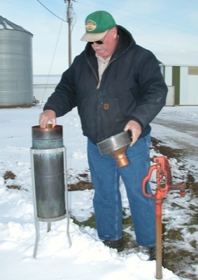
Dennis Howick of Celina checks the rain gauge near his home following a recent snowfall in the Grand Lake area. Howick took over the job as volunteer climate observer for the National Weather Service after his father, Harold Howick, retired in 2000.

Related online story:


A noisy goat peers out from a nearby wire pen as Dennis Howick checks his government-issued rain gauge for precipitation.
His modest rural Celina f [More]
Additional pictures on this date