Flood Advisory issued August 10 at 10:45PM EDT until August 11 at 1:45AM EDT by NWS Wilmington OH (details ...)
* WHAT...Flooding caused by excessive rainfall is expected.
* WHERE...Northwestern Auglaize County in west central Ohio... Northern Mercer County in west central Ohio...
* WHEN...Until 145 AM EDT.
* IMPACTS...Minor flooding in low-lying and poor drainage areas.
* ADDITIONAL DETAILS... - At 1045 PM EDT, radar indicated heavy rain due to thunderstorms. Minor flooding is ongoing or expected to begin shortly in the advisory area. Between 0.5 and 2 inches of rain have fallen. Additional rainfall amounts up to 2 inches are possible. - Some locations that may experience flooding include... Celina, St. Marys, Rockford, Moulton, Mendon, Buckland, Neptune, Tama, State Route 116 at State Route 197, Kossuth and Chattanooga.
Severe Thunderstorm Watch issued August 10 at 7:26PM EDT until August 11 at 2:00AM EDT by NWS Wilmington OH (details ...)
THE NATIONAL WEATHER SERVICE HAS ISSUED SEVERE THUNDERSTORM WATCH 560 IN EFFECT UNTIL 2 AM EDT TUESDAY FOR THE FOLLOWING AREAS
IN INDIANA THIS WATCH INCLUDES 1 COUNTY
IN EAST CENTRAL INDIANA
WAYNE
IN OHIO THIS WATCH INCLUDES 21 COUNTIES
IN CENTRAL OHIO
DELAWARE FAIRFIELD FAYETTE FRANKLIN HOCKING LICKING MADISON PICKAWAY UNION
IN WEST CENTRAL OHIO
AUGLAIZE CHAMPAIGN CLARK DARKE GREENE HARDIN LOGAN MERCER MIAMI MONTGOMERY PREBLE SHELBY
THIS INCLUDES THE CITIES OF ADA, BEAVERCREEK, BELLEFONTAINE, CAMDEN, CELINA, CIRCLEVILLE, COLDWATER, DELAWARE, DOWNTOWN COLUMBUS, DOWNTOWN DAYTON, EATON, FAIRBORN, GREENVILLE, KENTON, KETTERING, LANCASTER, LOGAN, LONDON, MARYSVILLE, MINSTER, NEW BREMEN, NEWARK, PICKERINGTON, PIQUA, PLAIN CITY, RICHMOND, SIDNEY, SPRINGFIELD, ST. MARYS, TIPP CITY, TROY, URBANA, WAPAKONETA, WASHINGTON COURT HOUSE, WEST JEFFERSON, AND XENIA.
Flood Watch issued August 10 at 1:04PM EDT until August 12 at 8:00AM EDT by NWS Wilmington OH (details ...)
* WHAT...Flash flooding caused by excessive rainfall is possible.
* WHERE...Portions of Indiana, including the following counties, Dearborn, Fayette, Franklin, Union and Wayne, Kentucky, including the following counties, Boone, Bracken, Campbell, Kenton, Lewis, Mason, Pendleton and Robertson, and Ohio, including the following counties, Adams, Auglaize, Brown, Butler, Champaign, Clark, Clermont, Clinton, Darke, Delaware, Fairfield, Fayette, Franklin, Greene, Hamilton, Hardin, Highland, Hocking, Licking, Logan, Madison, Mercer, Miami, Montgomery, Pickaway, Pike, Preble, Ross, Scioto, Shelby, Union and Warren.
* WHEN...Through Wednesday morning.
* IMPACTS...Excessive runoff may result in flooding of rivers, creeks, streams, and other low-lying and flood-prone locations.
* ADDITIONAL DETAILS... - Several rounds of thunderstorms are expected through Tuesday night. Locally heavy rainfall can be expected with the potential for storms to repeatedly track over the same locations. This will result in the potential for flash flooding.
Flash Flood Warning issued August 10 at 11:11PM EDT until August 11 at 1:30AM EDT by NWS Wilmington OH (details ...)
At 1111 PM EDT, radar indicated thunderstorms producing heavy rain across the warned area. Between 2 and 4 inches of rain have fallen. Additional rainfall amounts up to 1 inch are possible. Flash flooding is ongoing or expected to begin shortly.
HAZARD...Flash flooding caused by thunderstorms.
SOURCE...Radar indicated.
IMPACT...Flash flooding of small creeks and streams, urban areas, highways, streets and underpasses as well as other poor drainage and low-lying areas.
Some locations that may experience flash flooding include... Bellefontaine, Kenton, West Liberty, Russells Point, De Graff, Lakeview, Waynesfield, Belle Center, West Mansfield, Chippewa Park, Northwood, Roundhead, Quincy, Mount Victory, Rushsylvania, Huntsville, Ridgeway, Valley Hi, Zanesfield and Big Springs.
69° 69° chance Tue 82° Tue 82° likely 66° 66° likely Wed 82° Wed 82° chance
Thursday, January 31st, 2008

A mountain of ice at Lake Campus

By Shelley Grieshop
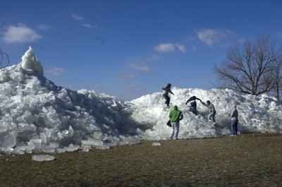
Photo by Mark Pummell/The Daily Standard

A group of Wright State University-Lake Campus students climb on the wind-blown ice covering the shoreline and dock behind the university Wednesday morning. The hill of ice, created by unusual wind and wave motion, was about 15 feet high.

An ice phenomena towering more than 15 feet high is drawing spectators to the Grand Lake shoreline near Wright State University-Lake Campus.
Sparkling slabs and hefty cubes of ice of all sizes - each averaging about 8 inches thick - were blown off Grand Lake during Tuesday evening's gusty storm. The glassy-looking cubes landed haphazardly on shore behind the branch campus along state Route 703.
"It's pretty weird," said Dr. Chuck Ciampaglio, a geologist and professor at the campus.
Ciampaglio spent a portion of his day Wednesday examining the ice oddity that stretched approximately 50 yards along the shore. He even brought his students to see it and learn about its formation, he added.
"Some pieces (of ice) were about 100 pounds or more," he said, adding weather conditions were just perfect to create what he called a "mini iceberg or glacier."
Unseasonably warm temperatures Sunday and Monday caused some melting and created "seams" in the ice on the lake, he said. The 50 mph-plus winds that arrived Tuesday evening easily pushed the partially-melted ice along in a northeasterly direction. The crescent-shaped shoreline behind the university funneled the flowing ice to that particular spot, he explained.
As the ice hit the shore, it began to form a slope that, piece by piece, became taller and taller and taller, he said. Many of the chunks came crashing down on the other side, spilling out across a walking path near a small inlet.
"The lake has some strange dynamics," Ciampaglio added.
Grand Lake St. Marys State Park Manager Craig Morton said a similar incident occurred at the lake a few years ago at the beach east of the state park office.
"As I remember, that one was about 15 to 16 feet tall," he said, adding the wind at that time also brought ashore boulders weighing 500 pounds.
Morton said he's seen the unusual ice formations reach more than 20 feet tall at Kelleys Island on Lake Erie, where he previously worked.
"There were some that threatened buildings on shore," he said. "They had to call out bulldozers and even dynamite to remove them. 'Course, that's not the case here."
At the Lake Campus, students periodically braved the bitter cold Wednesday to see and sometimes climb the structure. Morton said that's really not a good idea.
"The park strongly recommends that people stay off the ice piles. Somebody could get hurt," he said, advising the public to admire it safely from a distance.
The lake's newest tourist draw could disappear tonight beneath a coating of 4 to 8 inches of snow and ice, which is expected to strike late tonight and continue through Friday.
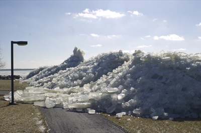
Photo by Mark Pummell/The Daily Standard

Ice chunks block the path along the Grand Lake shoreline behind the Wright State University-Lake Campus amphitheater on Wednesday.
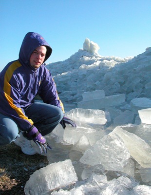
Photo by Shelley Grieshop/The Daily Standard

Jonathan Cheek of Rockford, a graphic design student at Wright State University-Lake Campus of Celina, poses near huge chunks of ice that landed on shore Tuesday night and Wednesday morning and created a towering presence to the rear of the campus. The unusual sight was due, in part, to the high winds that struck the local area overnight Tuesday.
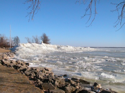
Photo by Shelley Grieshop/The Daily Standard

The shoreline behind Wright State University-Lake Campus in Celina is graced by a mountain of ice chunks, brought there by a combination of forces including high winds that blew across Grand Lake on Tuesday evening.


Additional online story on this date
The face of Celina High School's new football coach will be a familiar one, if the school board approves the hire at a 9:30 a.m. meeting Saturday as expected. [More]
Subscriber and paid stories on this date
Two local law enforcement professionals are in the final trio of candidates for the position of Minster police chief, to replace Chief Don Bergman who will retire after 12 years service.
St. Henry village council members will seek a face-to-face meeting with Ohio Department of Transportation (ODOT) officials after being disappointed with the state's speed changes for the two state routes that go through the village.
Compiled by Gary R. Rasberry
One advantage of playing a team later in the season is that a lot of scouting material is out there for a coach to go through.
Friday, 6:30 p.m. Cardinal Gymnasium
Last Game: The Indians held off a determined St. John's squad to go to 12-4 with a 58-50 win at Fort Site Fieldhouse. ... The Cardinals rebounded from Friday's overtime loss at Parkway to blow past Spencerville in the fourth quarter 53-40.
Friday, 6:30 p.m. Arnzen Gymnasium
Last Game: The Cavaliers improved to 9-5, beating Versailles 58-43 in a Monday night conference matchup. ... St. John's picked up a big 54-41 win at home against Lincolnview on Saturday night.
Friday, 6:30 p.m. Panther Gymnasium
Last Game: The Tigers lost to Coldwater 58-43 on Monday night. ... Parkway rebounded from getting outscored 10-2 in the final 23/4 minutes of regulation to beat New Bremen 70-64 last Friday.
Friday, 6:30 p.m. The Hangar
Last Game: The Wildcats gave up a fourth-quarter lead in falling to St. Henry 58-50 last Friday. ... After keeping a share of the MAC lead on Friday, the Flyers beat rival Fort Loraime 52-44 on Saturday night in Shelby County.
Friday, 6:30 p.m. Celina Fieldhouse
Last Game: The Wildcats came up with a big win over LimaLand rival LCC, winning 53-52 on Matt McKinney's last-second bucket at The Tub. ... Celina picked up its second straight win, beating Piqua 54-53 at the Fieldhouse on Hall of Fame Night.
Friday, 6:30 p.m. Lappin Gymnasium
Last Game: The Roughriders suffered their seventh loss in a row, falling 44-26 to Greenville on Saturday night. ... Shawnee saw first-half momentum evaporate in the third quarter, losing a MAC leader vs. WBL leader showdown at New Knoxville 73-52.