Severe Thunderstorm Warning issued August 10 at 10:45PM EDT until August 10 at 11:00PM EDT by NWS Wilmington OH (details ...)
At 1045 PM EDT, a severe thunderstorm was located near Rockford, moving southeast at 35 mph. HAZARD...60 mph wind gusts. SOURCE...Radar indicated. IMPACT...Expect damage to trees and power lines. Locations impacted include... Celina, St. Marys, Rockford, Mendon, Montezuma, Neptune, Kossuth, State Route 116 at State Route 197, Bulkhead, and Tama.
Flood Advisory issued August 10 at 10:45PM EDT until August 11 at 1:45AM EDT by NWS Wilmington OH (details ...)
* WHAT...Flooding caused by excessive rainfall is expected. * WHERE...Northwestern Auglaize County in west central Ohio... Northern Mercer County in west central Ohio... * WHEN...Until 145 AM EDT. * IMPACTS...Minor flooding in low-lying and poor drainage areas. * ADDITIONAL DETAILS... - At 1045 PM EDT, radar indicated heavy rain due to thunderstorms. Minor flooding is ongoing or expected to begin shortly in the advisory area. Between 0.5 and 2 inches of rain have fallen. Additional rainfall amounts up to 2 inches are possible. - Some locations that may experience flooding include... Celina, St. Marys, Rockford, Moulton, Mendon, Buckland, Neptune, Tama, State Route 116 at State Route 197, Kossuth and Chattanooga.
Severe Thunderstorm Warning issued August 10 at 10:39PM EDT until August 10 at 11:15PM EDT by NWS Wilmington OH (details ...)
SVRILN The National Weather Service in Wilmington has issued a * Severe Thunderstorm Warning for... Northwestern Shelby County in west central Ohio... Auglaize County in west central Ohio... Southern Mercer County in west central Ohio... * Until 1115 PM EDT. * At 1039 PM EDT, a severe thunderstorm was located near St. Marys, moving southeast at 40 mph. HAZARD...60 mph wind gusts. SOURCE...Radar indicated. IMPACT...Expect damage to trees and power lines. * Locations impacted include... Sidney, Wapakoneta, St. Marys, Coldwater, New Bremen, Minster, Anna, Fort Loramie, Jackson Center, Botkins, New Knoxville, Hardin, Moulton, Chickasaw, Buckland, Kettlersville, Montezuma, Fryburg, Montra, and Newbern. This includes I-75 in Ohio between mile markers 96 and 115.
Severe Thunderstorm Watch issued August 10 at 7:26PM EDT until August 11 at 2:00AM EDT by NWS Wilmington OH (details ...)
THE NATIONAL WEATHER SERVICE HAS ISSUED SEVERE THUNDERSTORM WATCH 560 IN EFFECT UNTIL 2 AM EDT TUESDAY FOR THE FOLLOWING AREAS IN INDIANA THIS WATCH INCLUDES 1 COUNTY IN EAST CENTRAL INDIANA WAYNE IN OHIO THIS WATCH INCLUDES 21 COUNTIES IN CENTRAL OHIO DELAWARE FAIRFIELD FAYETTE FRANKLIN HOCKING LICKING MADISON PICKAWAY UNION IN WEST CENTRAL OHIO AUGLAIZE CHAMPAIGN CLARK DARKE GREENE HARDIN LOGAN MERCER MIAMI MONTGOMERY PREBLE SHELBY THIS INCLUDES THE CITIES OF ADA, BEAVERCREEK, BELLEFONTAINE, CAMDEN, CELINA, CIRCLEVILLE, COLDWATER, DELAWARE, DOWNTOWN COLUMBUS, DOWNTOWN DAYTON, EATON, FAIRBORN, GREENVILLE, KENTON, KETTERING, LANCASTER, LOGAN, LONDON, MARYSVILLE, MINSTER, NEW BREMEN, NEWARK, PICKERINGTON, PIQUA, PLAIN CITY, RICHMOND, SIDNEY, SPRINGFIELD, ST. MARYS, TIPP CITY, TROY, URBANA, WAPAKONETA, WASHINGTON COURT HOUSE, WEST JEFFERSON, AND XENIA.
Flood Watch issued August 10 at 1:04PM EDT until August 12 at 8:00AM EDT by NWS Wilmington OH (details ...)
* WHAT...Flash flooding caused by excessive rainfall is possible. * WHERE...Portions of Indiana, including the following counties, Dearborn, Fayette, Franklin, Union and Wayne, Kentucky, including the following counties, Boone, Bracken, Campbell, Kenton, Lewis, Mason, Pendleton and Robertson, and Ohio, including the following counties, Adams, Auglaize, Brown, Butler, Champaign, Clark, Clermont, Clinton, Darke, Delaware, Fairfield, Fayette, Franklin, Greene, Hamilton, Hardin, Highland, Hocking, Licking, Logan, Madison, Mercer, Miami, Montgomery, Pickaway, Pike, Preble, Ross, Scioto, Shelby, Union and Warren. * WHEN...Through Wednesday morning. * IMPACTS...Excessive runoff may result in flooding of rivers, creeks, streams, and other low-lying and flood-prone locations. * ADDITIONAL DETAILS... - Several rounds of thunderstorms are expected through Tuesday night. Locally heavy rainfall can be expected with the potential for storms to repeatedly track over the same locations. This will result in the potential for flash flooding.
Flash Flood Warning issued August 10 at 10:30PM EDT until August 11 at 1:30AM EDT by NWS Wilmington OH (details ...)
FFWILN The National Weather Service in Wilmington has issued a * Flash Flood Warning for... Northwestern Union County in central Ohio... Northeastern Auglaize County in west central Ohio... Southern Hardin County in west central Ohio... Logan County in west central Ohio... Northeastern Shelby County in west central Ohio... * Until 130 AM EDT. * At 1030 PM EDT, radar indicated thunderstorms producing heavy rain across the warned area. Between 1 and 2.5 inches of rain have fallen. Additional rainfall amounts up to 2.5 inches are possible. Flash flooding is ongoing or expected to begin shortly. HAZARD...Flash flooding caused by thunderstorms. SOURCE...Radar indicated. IMPACT...Flash flooding of small creeks and streams, urban areas, highways, streets and underpasses as well as other poor drainage and low-lying areas. * Some locations that may experience flash flooding include... Bellefontaine, Kenton, West Liberty, Russells Point, De Graff, Lakeview, Waynesfield, Belle Center, West Mansfield, Chippewa Park, Northwood, Roundhead, Quincy, Mount Victory, Rushsylvania, Huntsville, Ridgeway, Valley Hi, Zanesfield and Big Springs.
The face of Celina High School's new football coach will be a familiar one, if the school board approves the hire at a 9:30 a.m. meeting Saturday as expected.
Jared Rolfes, a 2001 Celina graduate who now lives in Illinois, will be the 17th coach in the program's history after a seven-person committee searched through 60 applications for the position. He replaces coach Jerry Harris, who announced his retirement in November after two stints in coaching the Bulldogs (1981-1999 and 2006-2007). [More]
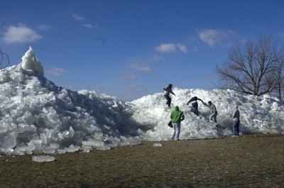
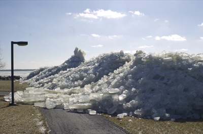
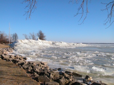
An ice phenomena towering more than 15 feet high is drawing spectators to the Grand Lake shoreline near Wright State University-Lake Campus.
Sparkling slabs and hefty cubes of ice of all sizes - each averaging about 8 inches thick - were blown off Grand Lake during Tuesday evening's gusty storm. The glassy-looking cubes landed haphazardly on shore behind the branch campus along state Route 703. [More]
Two local law enforcement professionals are in the final trio of candidates for the position of Minster police chief, to replace Chief Don Bergman who will retire after 12 years service.
St. Henry village council members will seek a face-to-face meeting with Ohio Department of Transportation (ODOT) officials after being disappointed with the state's speed changes for the two state routes that go through the village.
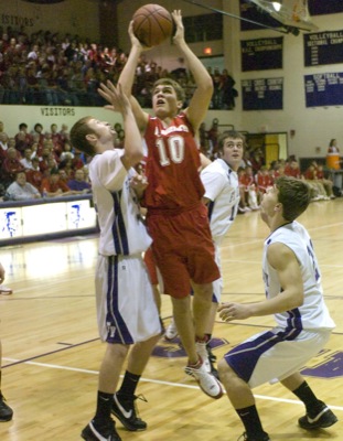
Last Game: The Indians held off a determined St. John's squad to go to 12-4 with a 58-50 win at Fort Site Fieldhouse. ... The Cardinals rebounded from Friday's overtime loss at Parkway to blow past Spencerville in the fourth quarter 53-40.
Last Game: The Cavaliers improved to 9-5, beating Versailles 58-43 in a Monday night conference matchup. ... St. John's picked up a big 54-41 win at home against Lincolnview on Saturday night.
Last Game: The Tigers lost to Coldwater 58-43 on Monday night. ... Parkway rebounded from getting outscored 10-2 in the final 23/4 minutes of regulation to beat New Bremen 70-64 last Friday.
Last Game: The Wildcats gave up a fourth-quarter lead in falling to St. Henry 58-50 last Friday. ... After keeping a share of the MAC lead on Friday, the Flyers beat rival Fort Loraime 52-44 on Saturday night in Shelby County.
Last Game: The Wildcats came up with a big win over LimaLand rival LCC, winning 53-52 on Matt McKinney's last-second bucket at The Tub. ... Celina picked up its second straight win, beating Piqua 54-53 at the Fieldhouse on Hall of Fame Night.
Last Game: The Roughriders suffered their seventh loss in a row, falling 44-26 to Greenville on Saturday night. ... Shawnee saw first-half momentum evaporate in the third quarter, losing a MAC leader vs. WBL leader showdown at New Knoxville 73-52.