Flood Watch issued August 15 at 10:25PM EDT until August 16 at 8:00AM EDT by NWS Wilmington OH (details ...)
* WHAT...Flash flooding caused by excessive rainfall continues to be possible.
* WHERE...Portions of Indiana, including the following counties, Fayette, Franklin, Union and Wayne and Ohio, including the following counties, Adams, Auglaize, Butler, Champaign, Clark, Clinton, Darke, Delaware, Fairfield, Fayette, Franklin, Greene, Hardin, Highland, Hocking, Licking, Logan, Madison, Mercer, Miami, Montgomery, Pickaway, Pike, Preble, Ross, Scioto, Shelby, Union and Warren.
* WHEN...Until 8 AM EDT Sunday.
* IMPACTS...Excessive runoff may result in flooding of rivers, creeks, streams, and other low-lying and flood-prone locations.
* ADDITIONAL DETAILS... - Additional rounds of showers and thunderstorms are possible tonight. Locally heavy rainfall may result in flash flooding.
Today 81° Today 81° chance likely 71° 71° chance Tomorrow 77° Tomorrow 77° slight chance 64° 64°
Friday, December 5th, 2008
Submitted Photo

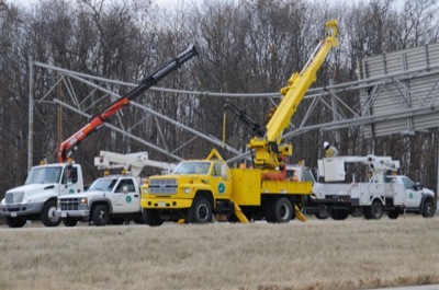
John Hemp of Sidney took this picture of the overpass signs knocked down by a truck driver on Thursday afternoon.


Related online story:
A dump truck driver who forgot to lower his truck bed and hit an overpass sign on U.S. 33 closed down traffic for four hours on Thursday afternoon.
The accident occurred around noon near the state Route 66 exit. [More]
Additional pictures on this date