Special Weather Statement issued May 18 at 4:44PM EDT by NWS Wilmington OH (details ...)
At 444 PM EDT, strong thunderstorms were located along a line extending from near Spencerville In Allen County to near Union City, moving east at 30 mph.
HAZARD...Wind gusts up to 50 mph, pea size hail, frequent cloud-to-ground lightning, and very heavy rain.
SOURCE...Radar indicated.
IMPACT...Gusty winds could knock down tree limbs and blow around unsecured objects. Hail may cause minor damage to vegetation. Lightning can cause serious injury or death. Visibility will be poor and hydroplaning is possible.
Locations impacted include... Greenville, Celina, Wapakoneta, St. Marys, Coldwater, Fort Shawnee, New Bremen, St. Henry, Cridersville, Union City, Ansonia, New Knoxville, Moulton, Wayne Lakes, Mendon, Chickasaw, Burkettsville, North Star, Buckland, and Rossburg.
This includes I-75 in Ohio between mile markers 114 and 118.
If outdoors, consider seeking shelter inside a sturdy building.
Motorists should slow down and use extra caution.
When thunder roars, go indoors! Do not stay in the open or seek shelter under trees when lightning threatens.
A Severe Thunderstorm Watch remains in effect until 600 PM EDT for west central Ohio.
To report hazardous weather conditions, go to our website at weather.gov/iln and submit your report via social media, when you can do so safely.
Special Weather Statement issued May 18 at 4:38PM EDT by NWS Wilmington OH (details ...)
At 438 PM EDT, strong thunderstorms were located along a line extending from 7 miles west of Fort Loramie to near Greenville, moving northeast at 40 mph.
HAZARD...Wind gusts up to 40 mph and pea size hail.
SOURCE...Radar indicated.
IMPACT...Gusty winds could knock down tree limbs and blow around unsecured objects. Hail may cause minor damage to vegetation.
Locations impacted include... Greenville, Wapakoneta, New Bremen, Minster, Versailles, Newport, Bradford, Fort Loramie, New Knoxville, Webster, Wayne Lakes, Russia, Gettysburg, Osgood, North Star, Kettlersville, Yorkshire, Egypt, Darke County Airport, and State Route 47 at US Route 127.
If outdoors, consider seeking shelter inside a sturdy building.
A Severe Thunderstorm Watch remains in effect until 600 PM EDT for west central Ohio.
To report hazardous weather conditions, go to our website at weather.gov/iln and submit your report via social media, when you can do so safely.
Severe Thunderstorm Watch issued May 18 at 11:11AM EDT until May 18 at 6:00PM EDT by NWS Wilmington OH (details ...)
THE NATIONAL WEATHER SERVICE HAS ISSUED SEVERE THUNDERSTORM WATCH 220 IN EFFECT UNTIL 6 PM EDT THIS EVENING FOR THE FOLLOWING AREAS
IN OHIO THIS WATCH INCLUDES 2 COUNTIES
IN WEST CENTRAL OHIO
AUGLAIZE MERCER
THIS INCLUDES THE CITIES OF CELINA, COLDWATER, MINSTER, NEW BREMEN, ST. MARYS, AND WAPAKONETA.
Special Weather Statement issued May 18 at 5:03PM EDT by NWS Wilmington OH (details ...)
At 503 PM EDT, a strong thunderstorm was located over Cridersville, moving northeast at 45 mph.
HAZARD...Wind gusts up to 45 mph, half inch hail, frequent cloud-to-ground lightning, and very heavy rain.
SOURCE...Radar indicated.
IMPACT...Gusty winds could knock down tree limbs and blow around unsecured objects. Hail may cause minor damage to vegetation. Lightning can cause serious injury or death. Visibility will be poor and hydroplaning is possible.
Locations impacted include... Wapakoneta, Ada, Fort Shawnee, Cridersville, Forest, Dunkirk, Alger, Waynesfield, Moulton, Blanchard, Mcguffey, Buckland, Uniopolis, Dola, Fryburg, Kossuth, Huntersville, St. Johns, Walton, and State Route 116 at State Route 197.
This includes I-75 in Ohio between mile markers 106 and 118.
If outdoors, consider seeking shelter inside a sturdy building.
Motorists should slow down and use extra caution.
When thunder roars, go indoors! Do not stay in the open or seek shelter under trees when lightning threatens.
A Severe Thunderstorm Watch remains in effect until 600 PM EDT for west central Ohio.
To report hazardous weather conditions, go to our website at weather.gov/iln and submit your report via social media, when you can do so safely.
Today 87° Today 87° chance 68° 68° chance Tomorrow 87° Tomorrow 87° likely 59° 59°
Monday, January 5th, 2009
Obituaries on January 5th, 2009
Ruth Ann Behr, 71, of Eastview Drive, Fort Loramie, died at 4:45 p.m. Jan. 3, 2009, at Wayne Hospital, Greenville. [More]
Mary Ann Harris, 72, of Rockford, died at 9:15 p.m. Jan. 2, 2009, at Van Wert County Hospital. [More]
Former Coldwater resident Victoria C. Knapke, 92, died at 2:41 p.m. Jan. 3, 2009, at The Gardens at Celina. [More]
Anna M. Steinbrunner, 90, 2646 Sawmill Road, Fort Recovery, died at 12:10 p.m. Jan. 3, 2009, at Mercer County Community Hospital, Coldwater. [More]
Virginia June Thornburg, 89, of Celina, died at 6:27 p.m. Jan. 2, 2009, at Celina Manor Nursing Home. [More]
Stories on January 5th, 2009
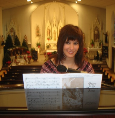
EGYPT - Organ music fills St. Joseph Catholic Church as members of the congregation arrive for Sunday morning Mass.
The dark-haired teenager at the organ console smiles as her fingers caress two rows of ivory keys and her feet move flawlessly over long wood pedals. [More]
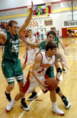
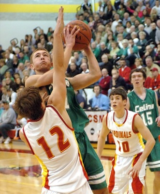
NEW BREMEN - New Bremen boys basketball coach Mike Ernst lamented after the game that his team finally got on board against Celina in the fourth quarter.
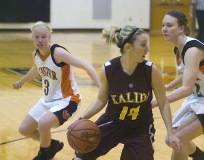
MINSTER - Heading into Saturday afternoon's contest at Minster Middle School, the home-standing Wildcats were in search of a kick start to their season.
Compiled by Gary R. Rasberry
Craig Tobe's bunny as time expried in overtime allowed Fort Recovery to raise its winning streak to four straight in
Local pictures on January 5th, 2009