Special Weather Statement issued September 16 at 12:38AM EDT by NWS Wilmington OH (details ...)
At 1237 AM EDT, a strong thunderstorm was located near Berne, moving east at 30 mph.
HAZARD...Wind gusts up to 40 mph and pea size hail.
SOURCE...Radar indicated.
IMPACT...Gusty winds could knock down tree limbs and blow around unsecured objects. Hail may cause minor damage to vegetation.
Locations impacted include... Rockford, Mendon, Chattanooga, and Tama.
If outdoors, consider seeking shelter inside a sturdy building.
To report hazardous weather conditions, go to our website at weather.gov/iln and submit your report via social media, when you can do so safely.
70° 70° slight chance chance Wed 86° Wed 86° chance 69° 69° slight chance chance Thu 84° Thu 84° likely
Friday, January 30th, 2009
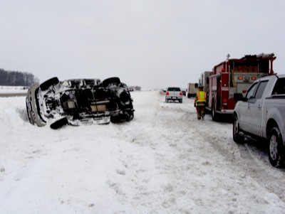
Rollover
Photo by Julie Metz/The Daily Standard

A 2002 GM Envoy rests on its side along state Route 29, east of Riley Road, following an accident at 1:56 p.m. Thursday. Andrea N. Clark, 27, 901 Magnolia St., St. Marys, lost control of the vehicle while driving eastbound in the left lane. The vehicle rotated off the road and overturned. Passing motorists helped Clark and her two young daughters - ages 31/2 and 11/2 - from the wreckage. The Mercer County Sheriff's Office report listed no injuries. A tow truck was called to remove the moderately damaged vehicle. Authorities handled more than 20 reports of disabled vehicles/accidents between 7 a.m. Thursday and 7:40 a.m. today.

Additional pictures on this date