Special Weather Statement issued May 1 at 12:13PM EDT by NWS Wilmington OH (details ...)
At 1212 PM EDT, a strong thunderstorm was located near New Bremen, moving northeast at 50 mph.
HAZARD...Wind gusts up to 45 mph and pea size hail.
SOURCE...Radar indicated.
IMPACT...Gusty winds could knock down tree limbs and blow around unsecured objects. Hail may cause minor damage to vegetation.
Locations impacted include... Newport, Fryburg, Montra, Egypt, Uniopolis, New Bremen, Buckland, Botkins, New Knoxville, Fort Loramie, Kettlersville, Moulton, Jackson Center, St. Marys, Anna, Kossuth, Lakeview, Lake Loramie State Park, Waynesfield, and Wapakoneta.
This includes I-75 in Ohio between mile markers 96 and 118.
If outdoors, consider seeking shelter inside a sturdy building.
To report hazardous weather conditions, go to our website at weather.gov/iln and submit your report via social media, when you can do so safely.
Today 74° Today 74° 58° 58° chance Tomorrow 71° Tomorrow 71° chance 54° 54° chance
Wednesday, March 11th, 2009
Windy night
Photo by Mark Pummell/The Daily Standard

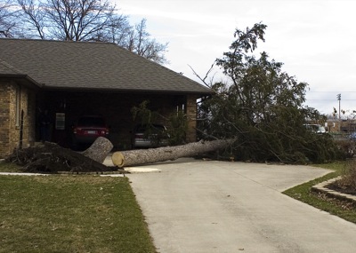
A tree came down in front of a home on Wayne Street in Celina overnight. A spokesman at the National Weather Service at Wilmington this morning said numerous wind damage reports have come in for the local area, including two semitrailers overturned on U.S. 127, trees down on state Route 703, among others. The wind gust of 45 mph that went through at about 12:30 a.m. this morning is the likely cause of the damage, the spokesman said. The weather service had issued a severe thunderstorm warning for 12:25 a.m. to 1:30 a.m.

Additional pictures on this date