Special Weather Statement issued November 10 at 2:15AM EST by NWS Wilmington OH (details ...)
Light snow across the area early this morning will increase in coverage and intensity toward sunrise in the I-70 corridor. This band of moderate snow will push south affecting the Tri-State region by mid morning, eventually pushing south of the area by early to mid afternoon.
Snow amounts of 1-2 inches will common for a good portion of the area on grassy surfaces, with melting on concrete surfaces limiting accumulations. Main impacts are expected to be reduced visibilities and some slick spots on mainly bridges and overpasses.
Temperatures today will remain steady mainly in the upper 20s. These cold temperatures combined with gusty winds of 20-25 mph will result in wind chill values in the teens to lower 20s.
Motorists should exercise caution. Plan extra time for the Monday morning commute.
25° 25° Mon 32° Mon 32° 22° 22° likely Tue 39° Tue 39° slight chance
Wednesday, October 21st, 2009
Photo by Mark Pummell/The Daily Standard

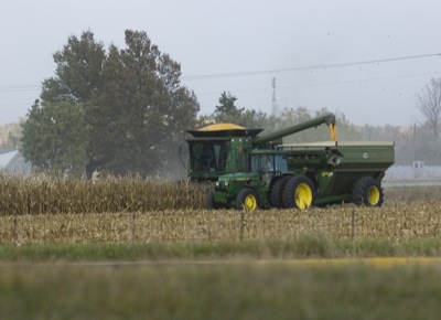
A farmer harvests corn west of St. Marys on Tuesday evening. Wet fall weather may have some farmers taking off corn well into November and spending extra money on drying costs, local ag officials have said.

Related online story:
Local farmers may be harvesting corn into late November due to a wet fall that's kept them out of the fields.
Add that to this year's drought and lackluster yields, and a lot of producers are wringing their hands, local ag officials say. [More]
Additional pictures on this date