Flood Watch issued August 15 at 2:16AM EDT until August 16 at 8:00AM EDT by NWS Wilmington OH (details ...)
* WHAT...Flash flooding caused by excessive rainfall continues to be possible.
* WHERE...Portions of Indiana, including the following counties, Fayette, Franklin, Union and Wayne and Ohio, including the following counties, Auglaize, Butler, Champaign, Clark, Clinton, Darke, Delaware, Fairfield, Fayette, Franklin, Greene, Hardin, Hocking, Licking, Logan, Madison, Mercer, Miami, Montgomery, Pickaway, Preble, Ross, Shelby, Union and Warren.
* WHEN...From noon EDT today through Sunday morning.
* IMPACTS...Excessive runoff may result in flooding of rivers, creeks, streams, and other low-lying and flood-prone locations.
* ADDITIONAL DETAILS... - Additional rounds of showers and thunderstorms are expected today and tonight. Heavy rainfall is possible, especially tonight, which may result in flash flooding.
Today 81° Today 81° likely 73° 73° likely Tomorrow 83° Tomorrow 83° chance 70° 70° chance
Wednesday, April 28th, 2010
Photo by Mark Pummell/The Daily Standard

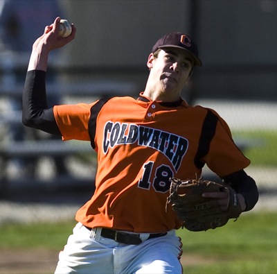
Coldwater's Reese Klenke delivers a pitch to the plate against Minster in a battle of unbeaten Midwest Athletic Conference teams on Tuesday at Veterans Field. Klenke pitched six strong innings in the Cavaliers' 4-1 win.


Additional pictures on this date