Flood Watch issued August 15 at 10:25PM EDT until August 16 at 8:00AM EDT by NWS Wilmington OH (details ...)
* WHAT...Flash flooding caused by excessive rainfall continues to be possible.
* WHERE...Portions of Indiana, including the following counties, Fayette, Franklin, Union and Wayne and Ohio, including the following counties, Adams, Auglaize, Butler, Champaign, Clark, Clinton, Darke, Delaware, Fairfield, Fayette, Franklin, Greene, Hardin, Highland, Hocking, Licking, Logan, Madison, Mercer, Miami, Montgomery, Pickaway, Pike, Preble, Ross, Scioto, Shelby, Union and Warren.
* WHEN...Until 8 AM EDT Sunday.
* IMPACTS...Excessive runoff may result in flooding of rivers, creeks, streams, and other low-lying and flood-prone locations.
* ADDITIONAL DETAILS... - Additional rounds of showers and thunderstorms are possible tonight. Locally heavy rainfall may result in flash flooding.
70° 70° chance Sun 82° Sun 82° slight chance 68° 68° chance Mon 77° Mon 77° chance
Wednesday, September 15th, 2010
Photo by Mark Pummell/The Daily Standard

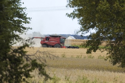
A farmer harvests soybeans Tuesday along U.S. 33 east of Neptune. Crops in Mercer and Auglaize counties are coming off earlier this year due to early planting and early maturation from the dry weather.

Related online story:


Area farmers have begun harvesting corn and soybeans about two to three weeks early and the timetable may be financially beneficial.
Low moisture content in the crops will save growers money in drying costs and market prices are higher than normal right now, local ag officials say. [More]
Additional pictures on this date