Winter Storm Watch issued January 22 at 1:34PM EST until January 26 at 1:00AM EST by NWS Wilmington OH (details ...)
* WHAT...Heavy snow possible. Total snow accumulations between 4 and 7 inches possible.
* WHERE...Auglaize, Darke, Hardin, Logan, Mercer, and Shelby Counties.
* WHEN...From Saturday morning through late Sunday night.
* IMPACTS...Travel could be very difficult.
Cold Weather Advisory issued January 22 at 12:34PM EST until January 23 at 12:00PM EST by NWS Wilmington OH (details ...)
* WHAT...Very cold wind chills as low as 13 below zero expected.
* WHERE...In Indiana, Wayne County. In Ohio, Auglaize, Darke, Hardin, Logan, Mercer, and Shelby Counties.
* WHEN...From 6 AM to noon EST Friday.
* IMPACTS...Wind chill values can lead to hypothermia with prolonged exposure.
* ADDITIONAL DETAILS...While temperatures are expected to be in the upper single digits (above zero), a northwest wind at 10-15 mph will make temperatures feel as if they are colder than 10 below zero.
Today 27° Today 27° Tomorrow Tomorrow -1° -1°
Monday, September 27th, 2010
Submitted Photo

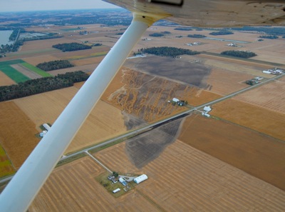
This aerial photo shows the extent of damage from an out-of-control trash fire that spread across a mile-long area of rural St. Marys on Friday. Windy conditions caused the fire to jump two roadways, damage several structures and burn more than 100 acres of land. An area resident was treated at a local hospital for smoke inhalation.

Additional pictures on this date