Heat Advisory issued June 27 at 3:29AM EDT until June 27 at 8:00PM EDT by NWS Wilmington OH (details ...)
* WHAT...Heat index values up to 100.
* WHERE...Portions of east central and southeast Indiana, northeast and northern Kentucky, and central, south central, southwest, and west central Ohio.
* WHEN...Until 8 PM EDT this evening.
* IMPACTS...Hot temperatures and high humidity may cause heat illnesses.
Today 90° Today 90° chance 73° 73° chance Tomorrow 85° Tomorrow 85° slight chance chance 71° 71° slight chance
Friday, May 27th, 2011
Storm clouds
Photo by Shelley Grieshop/The Daily Standard

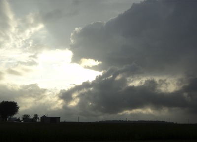
Storm clouds hang low as the sun attempts to break through to the west of Coldwater on Thursday night while tornado sirens sound in the village. A small "cold-air" funnel cloud, which is considered weak and short-lived, temporarily touched down in the Burkettsville area about 7:30 p.m. but no damage was reported as it moved northeast. Tornado sirens also went off in St. Henry, Coldwater, Chickasaw, Montezuma, New Bremen and St. Marys. No damage was reported in those villages either.

Additional pictures on this date