Special Weather Statement issued May 1 at 12:13PM EDT by NWS Wilmington OH (details ...)
At 1212 PM EDT, a strong thunderstorm was located near New Bremen, moving northeast at 50 mph.
HAZARD...Wind gusts up to 45 mph and pea size hail.
SOURCE...Radar indicated.
IMPACT...Gusty winds could knock down tree limbs and blow around unsecured objects. Hail may cause minor damage to vegetation.
Locations impacted include... Newport, Fryburg, Montra, Egypt, Uniopolis, New Bremen, Buckland, Botkins, New Knoxville, Fort Loramie, Kettlersville, Moulton, Jackson Center, St. Marys, Anna, Kossuth, Lakeview, Lake Loramie State Park, Waynesfield, and Wapakoneta.
This includes I-75 in Ohio between mile markers 96 and 118.
If outdoors, consider seeking shelter inside a sturdy building.
To report hazardous weather conditions, go to our website at weather.gov/iln and submit your report via social media, when you can do so safely.
Today 74° Today 74° 58° 58° chance Tomorrow 71° Tomorrow 71° chance 54° 54° chance
Friday, June 10th, 2011
Photo by Mark Pummell/The Daily Standard

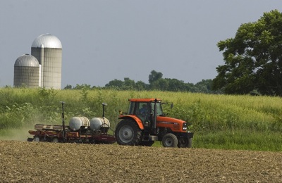
A farmer plants soybeans in a field off Fleetfoot south of Coldwater Thursday evening. Local ag officials estimate most of the corn and more than half the soybeans have been planted in the county in the last week after almost continuous rain stopped. A soaker this morning gave some of the seeds a much-needed drink.

Related online story:
Dennis Howick is feeling a little bit better than he was in the middle of May when his seeds were sitting in his barn as rain battered the area.
Sunny, dry weather in the last two weeks changed the circumstance. [More]
Additional pictures on this date