Cold Weather Advisory issued January 27 at 2:29AM EST until January 28 at 12:00PM EST by NWS Wilmington OH (details ...)
* WHAT...For the Extreme Cold Warning, dangerously cold wind chills as low as 25 below zero. For the Cold Weather Advisory, very cold wind chills as low as 20 below zero expected.
* WHERE...Portions of east central and southeast Indiana, northeast and northern Kentucky, and central, south central, southwest, and west central Ohio.
* WHEN...For the Extreme Cold Warning, until noon EST today. For the Cold Weather Advisory, from 7 PM this evening to noon EST Wednesday.
* IMPACTS...Dangerously cold wind chills as low as 20 below zero could cause frostbite on exposed skin in as little as 30 minutes.
Extreme Cold Warning issued January 27 at 2:29AM EST until January 27 at 12:00PM EST by NWS Wilmington OH (details ...)
* WHAT...For the Extreme Cold Warning, dangerously cold wind chills as low as 25 below zero. For the Cold Weather Advisory, very cold wind chills as low as 20 below zero expected.
* WHERE...Portions of east central and southeast Indiana, northeast and northern Kentucky, and central, south central, southwest, and west central Ohio.
* WHEN...For the Extreme Cold Warning, until noon EST today. For the Cold Weather Advisory, from 7 PM this evening to noon EST Wednesday.
* IMPACTS...Dangerously cold wind chills as low as 20 below zero could cause frostbite on exposed skin in as little as 30 minutes.
-7° -7° patchy blowing Tue 18° Tue 18° patchy blowing -8° -8° patchy blowing Wed 12° Wed 12°
Wednesday, June 15th, 2011
Photo by Shelley Grieshop/The Daily Standard

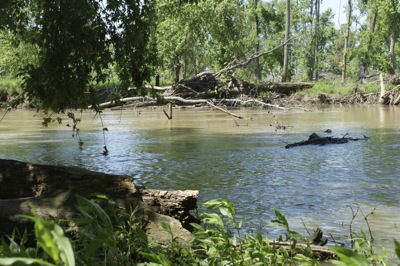
Large trees, branches and other debris impede the flow of the St. Marys River north of U.S. 33 along Township Line Road. Mercer County officials took steps this week to implement a logjam removal project.

Related online story:
CELINA - Officials finally have enough money to work on logjams that block the flow of the winding St. Marys River and contribute to periodic flooding. [More]
Additional pictures on this date