The Daily Standard
Pictures Archive

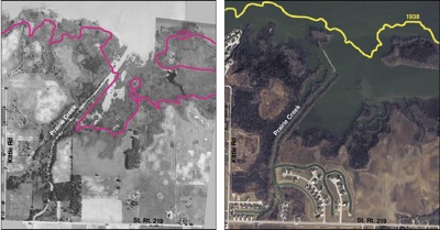
These aerial photos of the Prairie Creek area on the south side of Grand Lake show the loss of littoral wetlands in 70 years. The photo on the left is from 1938 and the magenta line marks the current shore line. The photo on the right is from 2009 and the 1938 shore line is marked in yellow. By 1973, the wetlands disappeared due to land development, increased runoff and the loss of adequate vegetation along the shoreline, according to the Ohio EPA. Sources: 1938 photo from the Mercer County Engineer's Office, 2009 photo from the Mercer County Tax Map Department.
Related online story: