Special Weather Statement issued July 16 at 12:09PM EDT by NWS Wilmington OH (details ...)
Temperatures continue climb into the upper 80s to lower 90s today. This will combine with a humid airmass to produce heat indicies in the 95 to 100 degree range this afternoon. Take extra precautions when outside. Wear lightweight and loose fitting clothing. Try to limit strenuous activities to early morning or evening.
Air Quality Alert issued July 16 at 10:53AM EDT by NWS Wilmington OH (details ...)
The Ohio Environmental Protection Agency has issued an Air Quality Advisory for the entire state of Ohio, until midnight EDT tonight. Smoke from Canadian wildfires will adversely impact air quality today. The Ohio Environmental Protection Agency expects the Air Quality Index to be in the 'unhealthy' range. For additional information, please visit the Ohio Environmental Protection Agency's website at epa.ohio.gov.
Air Quality Alert issued July 16 at 9:21AM EDT by NWS Wilmington OH (details ...)
The Ohio Environmental Protection Agency has issued an Air Quality Advisory for the entire state of Ohio, until midnight EDT tonight. Smoke from Canadian wildfires will adversely impact air quality today. The Ohio Environmental Protection Agency expects the Air Quality Index to be in the 'unhealthy' range. For additional information, please visit the Ohio Environmental Protection Agency's website at epa.ohio.gov.
Air Quality Alert issued July 16 at 12:23AM EDT by NWS Wilmington OH (details ...)
The Ohio Environmental Protection Agency has issued an Air Quality Advisory for the entire state of Ohio, through midnight EDT tonight. Smoke from Canadian wildfires will adversely impact air quality. The Agency expects the Air Quality Index to be in the 'unhealthy for sensitive groups' range. For additional actions and information, please visit the Ohio Environmental Protection Agency's web site at epa.ohio.gov.
Air Quality Alert issued July 16 at 12:16AM EDT by NWS Wilmington OH (details ...)
The Ohio Environmental Protection Agency has issued an Air Quality Advisory for the entire state of Ohio, from 7 AM Thursday to midnight EDT tonight. Smoke from Canadian wildfires will adversely impact air quality. The Agency expects the Air Quality Index to be in the 'unhealthy for sensitive groups' range. For additional actions and information, please visit the Ohio Environmental Protection Agency's web site at epa.ohio.gov.
Air Quality Alert issued July 15 at 9:35PM EDT by NWS Wilmington OH (details ...)
The Ohio Environmental Protection Agency has issued an Air Quality Advisory for the entire state of Ohio, from 7 AM Thursday to midnight EDT Thursday night. Smoke from Canadian wildfires will adversely impact air quality. The Agency expects the Air Quality Index to be in the 'unhealthy for sensitive groups' range. For additional actions and information, please visit the Ohio Environmental Protection Agency's web site at epa.ohio.gov.
Thursday, October 27th, 2011
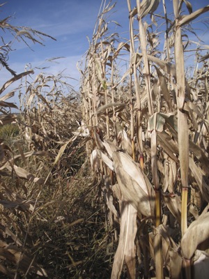
Awaiting harvest
Photo by Nancy Allen/The Daily Standard
Corn stands in a field northwest of Celina this week. Recent rains have put a damper on this year's already late harvest, kicking farmers out of their fields almost as soon as they got in. Despite the rain and wind, there are no reports of downed corn in Mercer or Auglaize counties. Most of the early crop soybeans are off in both counties, and about 15 percent of corn is harvested, ag officials say.