Flood Watch issued August 13 at 4:50AM EDT until August 14 at 11:00AM EDT by NWS Wilmington OH (details ...)
* WHAT...Flash flooding caused by excessive rainfall continues to be possible.
* WHERE...Portions of Indiana, including the following counties, Dearborn, Fayette, Franklin, Ohio, Ripley, Switzerland, Union and Wayne, Kentucky, including the following counties, Boone, Bracken, Campbell, Carroll, Gallatin, Grant, Kenton, Lewis, Mason, Owen, Pendleton and Robertson, and Ohio, including the following counties, Adams, Auglaize, Brown, Butler, Champaign, Clark, Clermont, Clinton, Darke, Delaware, Fairfield, Fayette, Franklin, Greene, Hamilton, Hardin, Highland, Hocking, Licking, Logan, Madison, Mercer, Miami, Montgomery, Pickaway, Pike, Preble, Ross, Scioto, Shelby, Union and Warren.
* WHEN...Through Friday morning.
* IMPACTS...Excessive runoff may result in flooding of rivers, creeks, streams, and other low-lying and flood-prone locations. Area creeks and streams are running high and could flood with more heavy rain.
* ADDITIONAL DETAILS... - A lull in rainfall will continue for much of the day. However, additional storms will move into the area later this afternoon. The risk of heavy rainfall will be greatest tonight into early Friday morning. There is also the potential for storms to repeatedly move over the same locations, which increases flash flood risk.
Today 83° Today 83° chance 69° 69° chance likely Tomorrow 81° Tomorrow 81° chance likely 68° 68° chance
Friday, November 18th, 2011
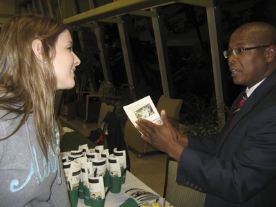
Photo by Amy Kronenberger/The Daily Standard

Fort Recovery High School senior Olivia Schwieterman, left, discusses the new mechanical engineering program at Wright State University-Lake Campus with P. Ruby Mawasha, assistant dean of engineering and computer sciences, during an open house Thursday.

Related online story:


Some local officials and recent political candidates cited brain drain as an issue for the Grand Lake area; however the 2010 Ohio Census tells another story. [More]
Additional pictures on this date