Special Weather Statement issued August 10 at 10:02AM EDT by NWS Wilmington OH (details ...)
At 1002 AM EDT, a strong thunderstorm was located near Waynesfield, moving southeast at 30 mph.
HAZARD...Wind gusts up to 40 mph and pea size hail.
SOURCE...Radar indicated.
IMPACT...Gusty winds could knock down tree limbs and blow around unsecured objects. Hail may cause minor damage to vegetation.
Locations impacted include... Sidney, Bellefontaine, Anna, Jackson Center, Russells Point, De Graff, Botkins, Lakeview, Waynesfield, Belle Center, West Mansfield, Chippewa Park, Northwood, Roundhead, Quincy, Rushsylvania, Mcguffey, Huntsville, Port Jefferson, and Valley Hi.
This includes I-75 in Ohio between mile markers 92 and 104.
If outdoors, consider seeking shelter inside a sturdy building.
To report hazardous weather conditions, go to our website at weather.gov/iln and submit your report via social media, when you can do so safely.
Today 84° Today 84° chance 68° 68° chance likely Tomorrow 82° Tomorrow 82° likely chance 67° 67° chance
Wednesday, May 28th, 2014
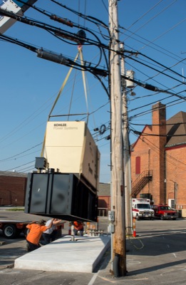
More power
Photo by Mark Pummell/The Daily Standard

With the assistance of Paysen Electric Service, the city installed a new generator outside the fire department this morning that has double the power provided by the previous generator. It will provide back-up power to the city's computer servers at city hall. The generator was included in this year's budget and is expected to cost between $80,000 to $90,000, according to Celina Mayor Jeff Hazel.


Additional pictures on this date