The Daily Standard
Pictures Archive
Menu
▼
Home
Subscribe
E-Edition
Archives
▼
Archives
Obituary Archives
Photo Albums
Podcasts
▼
Podcasts
Video
Classifieds
▼
Classifieds
Public Notices
Weather
Sports
More
▼
Contacts
Advertising
Subscription Payment
Community Pictures
Historical Maps
Forms
Locations
Elections
Today
68°
Today
68°
45°
45°
Tomorrow
69°
Tomorrow
69°
47°
47°
Monday, June 8th, 2015
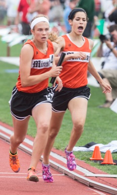
Photo by Mark Pummell/The Daily Standard
Minster's Maggie Meiring finished third in the 300-meter hurdles.
Related online story:
Wildcats set record, earn runner-up trophy
COLUMBUS - Saturday had already been a superb day for the Minster girls leading up to the final event at the Division III state track and field meet.
They saved the best for last. [
More
]
Purchase a print of this photo.
Archive of June 8th, 2015
Buy this E-Edition
Additional pictures on this date
<!--Unsupported browser-->
Copyright © 2026 Standard Printing Co. All Rights Reserved