Special Weather Statement issued May 1 at 12:13PM EDT by NWS Wilmington OH (details ...)
At 1212 PM EDT, a strong thunderstorm was located near New Bremen, moving northeast at 50 mph.
HAZARD...Wind gusts up to 45 mph and pea size hail.
SOURCE...Radar indicated.
IMPACT...Gusty winds could knock down tree limbs and blow around unsecured objects. Hail may cause minor damage to vegetation.
Locations impacted include... Newport, Fryburg, Montra, Egypt, Uniopolis, New Bremen, Buckland, Botkins, New Knoxville, Fort Loramie, Kettlersville, Moulton, Jackson Center, St. Marys, Anna, Kossuth, Lakeview, Lake Loramie State Park, Waynesfield, and Wapakoneta.
This includes I-75 in Ohio between mile markers 96 and 118.
If outdoors, consider seeking shelter inside a sturdy building.
To report hazardous weather conditions, go to our website at weather.gov/iln and submit your report via social media, when you can do so safely.
Today 74° Today 74° 58° 58° chance Tomorrow 71° Tomorrow 71° chance 54° 54° chance
Thursday, April 14th, 2016
Photo by Claire Giesige/The Daily Standard

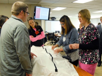
Mercer Health nursing supervisors work on tagging a CPR dummy during a mass-fatality drill. County officials gathered on Wednesday to run through a mass-fatality exercise, dealing with hypothetical crises such as supply shortages and hospital space limitations.

Related online story:
COLDWATER - "This is only a drill," Mercer County officials kept telling colleagues over the phone as they requested help in dealing with 41 fatalities in 48 hours. [More]
Additional pictures on this date