Severe Thunderstorm Watch issued April 14 at 5:01PM EDT until April 14 at 10:00PM EDT by NWS Wilmington OH (details ...)
THE NATIONAL WEATHER SERVICE HAS ISSUED SEVERE THUNDERSTORM WATCH 112 IN EFFECT UNTIL 10 PM EDT THIS EVENING FOR THE FOLLOWING AREAS
IN INDIANA THIS WATCH INCLUDES 4 COUNTIES
IN EAST CENTRAL INDIANA
FAYETTE UNION WAYNE
IN SOUTHEAST INDIANA
FRANKLIN
IN OHIO THIS WATCH INCLUDES 7 COUNTIES
IN WEST CENTRAL OHIO
AUGLAIZE DARKE MERCER MIAMI MONTGOMERY PREBLE SHELBY
THIS INCLUDES THE CITIES OF BROOKVILLE, CAMDEN, CELINA, COLDWATER, CONNERSVILLE, DOWNTOWN DAYTON, EATON, GREENVILLE, KETTERING, LIBERTY, MINSTER, NEW BREMEN, PIQUA, RICHMOND, SIDNEY, ST. MARYS, TIPP CITY, TROY, WAPAKONETA, AND WEST COLLEGE CORNER.
Today 82° Today 82° chance 67° 67° chance Tomorrow 83° Tomorrow 83° likely 66° 66° likely
Wednesday, May 3rd, 2017
Crash investigated
Photo by Tom Stankard/The Daily Standard

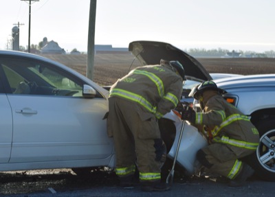
St. Henry Fire Department personnel respond to the scene of a three-car accident this morning at the intersection of Kremer-Hoying and Coldwater Creek roads near St. Henry. One person was reported to have suffered a possible broken arm. No other injuries were reported. Two of the three vehicles involved reportedly sustained disabling damage. Mercer County Sheriff's Department personnel cited failure to yield as the likely cause of the accident, which occurred at 7:35 a.m. More information was not available by press time.

Additional pictures on this date