Flood Watch issued August 13 at 10:22PM EDT until August 14 at 11:00AM EDT by NWS Wilmington OH (details ...)
* WHAT...Flash flooding caused by excessive rainfall continues to be possible.
* WHERE...Portions of Indiana, including the following counties, Dearborn, Fayette, Franklin, Ohio, Ripley, Switzerland, Union and Wayne, Kentucky, including the following counties, Boone, Bracken, Campbell, Carroll, Gallatin, Grant, Kenton, Lewis, Mason, Owen, Pendleton and Robertson, and Ohio, including the following counties, Adams, Auglaize, Brown, Butler, Champaign, Clark, Clermont, Clinton, Darke, Delaware, Fairfield, Fayette, Franklin, Greene, Hamilton, Hardin, Highland, Hocking, Licking, Logan, Madison, Mercer, Miami, Montgomery, Pickaway, Pike, Preble, Ross, Scioto, Shelby, Union and Warren.
* WHEN...Through Friday morning.
* IMPACTS...Excessive runoff may result in flooding of rivers, creeks, streams, and other low-lying and flood-prone locations. Area creeks and streams are running high and could flood with more heavy rain.
* ADDITIONAL DETAILS... - Additional storms will move into the area after midnight, persisting through late Friday morning. Heavy rain can be expected with these storms, with the risk of flash flooding increasing with storms that repeatedly move over the same locations.
Today 82° Today 82° likely chance 70° 70° chance Tomorrow 84° Tomorrow 84° chance 74° 74° chance likely
Monday, December 17th, 2007
Photo by Mark Pummell/The Daily Standard

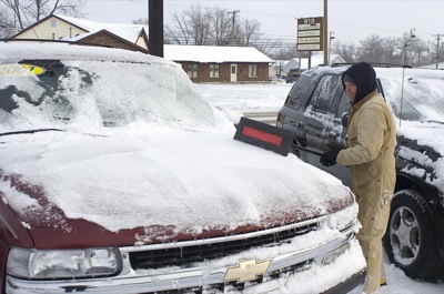
Mike Hatton removes snow from a vehicle on Kerns used car lot on Logan Street this morning. A weekend winter storm dumped a total of 6.7 inches of snow in the area this weekend, making driving hazardous and closing schools today.

Related online story:

Despite receiving nearly 7 inches of snow throughout the weekend, no serious accidents or incidents were reported across the Grand Lake area.
Schoo [More]
Additional pictures on this date