Special Weather Statement issued May 1 at 12:13PM EDT by NWS Wilmington OH (details ...)
At 1212 PM EDT, a strong thunderstorm was located near New Bremen, moving northeast at 50 mph.
HAZARD...Wind gusts up to 45 mph and pea size hail.
SOURCE...Radar indicated.
IMPACT...Gusty winds could knock down tree limbs and blow around unsecured objects. Hail may cause minor damage to vegetation.
Locations impacted include... Newport, Fryburg, Montra, Egypt, Uniopolis, New Bremen, Buckland, Botkins, New Knoxville, Fort Loramie, Kettlersville, Moulton, Jackson Center, St. Marys, Anna, Kossuth, Lakeview, Lake Loramie State Park, Waynesfield, and Wapakoneta.
This includes I-75 in Ohio between mile markers 96 and 118.
If outdoors, consider seeking shelter inside a sturdy building.
To report hazardous weather conditions, go to our website at weather.gov/iln and submit your report via social media, when you can do so safely.
Today 74° Today 74° 58° 58° chance Tomorrow 71° Tomorrow 71° chance 54° 54° chance
Tuesday, February 16th, 2010
Rather be sledding
Photo by Mark Pummell/The Daily Standard

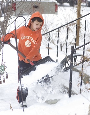
Hunter Markins, 10, shovels snow off his front steps on Portland Street in Celina this morning after learning he and other students in the region have another day off school due to the weather. Mercer County was placed under a Level 1 snow emergency at mid-morning today after forecasters predicted up to two inches of new snow today and wind gusts of 25 to 30 mph. Most area roadways remained snow-covered and drifting at press time today.

Additional pictures on this date