Flood Advisory issued August 12 at 10:55AM EDT until August 12 at 2:15PM EDT by NWS Wilmington OH (details ...)
* WHAT...Flooding caused by excessive rainfall continues.
* WHERE...Southwestern Auglaize County in west central Ohio... Darke County in west central Ohio... Mercer County in west central Ohio... Miami County in west central Ohio... Northeastern Preble County in west central Ohio... Western Shelby County in west central Ohio...
* WHEN...Until 215 PM EDT.
* IMPACTS...Minor flooding in low-lying and poor drainage areas.
* ADDITIONAL DETAILS... - At 1054 AM EDT, local law enforcement has reported minor flooding in the advisory area. Between 2 and 3 inches of rain have fallen. Additional rainfall amounts of 1 to 1.5 inches are possible. - Some locations that may experience flooding include... Troy, Piqua, Greenville, Celina, Tipp City, St. Marys, West Milton, Coldwater, New Bremen, Minster, Versailles, Covington, St. Henry, Arcanum, Newport, Bradford, Union City, Fort Loramie, Fort Recovery and Pleasant Hill.
Flood Watch issued August 12 at 9:17AM EDT until August 12 at 11:00PM EDT by NWS Wilmington OH (details ...)
* WHAT...Flash flooding caused by excessive rainfall continues to be possible.
* WHERE...Portions of Indiana, including the following counties, Dearborn, Fayette, Franklin, Ohio, Ripley, Switzerland, Union and Wayne, Kentucky, including the following counties, Boone, Bracken, Campbell, Carroll, Gallatin, Grant, Kenton, Lewis, Mason, Owen, Pendleton and Robertson, and Ohio, including the following counties, Adams, Auglaize, Brown, Butler, Champaign, Clark, Clermont, Clinton, Darke, Delaware, Fairfield, Fayette, Franklin, Greene, Hamilton, Hardin, Highland, Hocking, Licking, Logan, Madison, Mercer, Miami, Montgomery, Pickaway, Pike, Preble, Ross, Scioto, Shelby, Union and Warren.
* WHEN...Through this evening.
* IMPACTS...Excessive runoff may result in flooding of rivers, creeks, streams, and other low-lying and flood-prone locations.
* ADDITIONAL DETAILS... - Additional thunderstorms are expected into this evening. Locally heavy rainfall and the potential for storms to repeatedly track over the same areas are possible. This will result in the potential for flash flooding.
Today 83° Today 83° likely 68° 68° slight chance chance Tomorrow 81° Tomorrow 81° chance chance 68° 68° chance
Monday, November 17th, 2014
Large crowd fills church to learn about new artifact
By William Kincaid
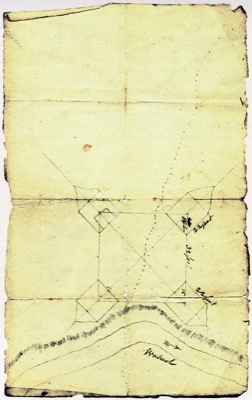
FORT RECOVERY - An original construction plan for Fort Recovery has been found to the surprise and elation of historians and museum officials.
A large crowd of both locals and out-of-town history enthusiasts packed the Fort Recovery Nazarene Churc [More]
Obituaries on November 17th, 2014
Joyce Ann Hone, 84, Celina, died at 6:55 p.m. Nov. 14, 2014, at The Gardens, Celina. [More]
William H. Tuttle, 83, Spencerville, died Nov. 15, 2014, at Roselawn Manor Nursing Home, Spencerville. [More]
Local pictures on November 17th, 2014
Subscriber stories on November 17th, 2014
CELINA - The area saw 3.8 inches of snow fall from early Sunday night into Monday morning, and law-enforcement officers reported a few accidents resulting in minor injuries.
CELINA - Celina police officers are seeking the public's help in their search for a missing man.
Police chief Tom Wale said Kevin Davis, 24, who had been staying at a Morton Street home, had left a Deford Street home Friday night.
Division VII Football Regional Semifinal
WAPAKONETA - Marion Local's mission for a fourth consecutive state title took another step forward on Saturday night.
Fort Recovery's historic season ended as a result.
Division V Football Regional Semifinal
TIFFIN - A couple big hits to Brody Hoying resulted in a few scary moments for Coldwater fans. But that didn't keep Hoying off the football field for too long, or for that matter, out of the end zone.