St Marys shooting 911 call
More videos you may like:
video poster pict
Fatal shooting in Celina
December 31, 2024
video poster pict
4-H Animal projects
July 22, 2024
video poster pict
Total Solar Eclipse
April 8, 2024
Audio Recording:
Tuesday, February 11th, 2020
6:24
Audio

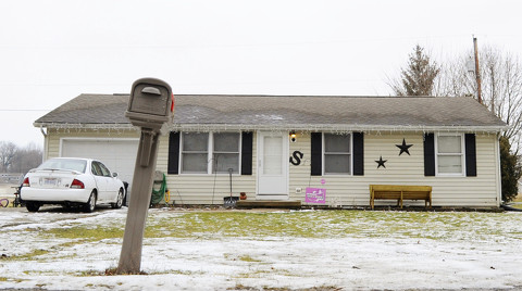
The Auglaize County Sheriff's Department has released the 911 call reporting the shooting death of Wesley Sweigart, a rural St. Marys man on Saturday. Stephanie Sweigart, the man's wife, has been arrested on a charge of murder. Here is a copy of the recording, edited to remove personal identification information.

In the call Stephanie Sweigart states that Wesley Sweigart was attacking her, and that she killed him.

More information is available in our Monday story and our Tuesday story.

Flood Advisory issued July 27 at 1:10PM EDT until July 27 at 4:15PM EDT by NWS Wilmington OH (details ...)
* WHAT...Flooding caused by excessive rainfall is expected.
* WHERE...The following counties, in west central Ohio, Auglaize and Mercer.
* WHEN...Until 415 PM EDT.
* IMPACTS...Minor flooding in low-lying and poor drainage areas.
* ADDITIONAL DETAILS... - At 110 PM EDT, radar indicated heavy rain due to thunderstorms. Minor flooding is ongoing or expected to begin shortly in the advisory area. Between 1 and 2 inches of rain have fallen. Additional rainfall amounts of 0.5 to 1 inch are possible. - Some locations that may experience flooding include... Coldwater, New Bremen, Minster, St. Henry, Fort Recovery, New Knoxville, Chickasaw, Montezuma, Carthagena and Maria Stein.
Flash Flood Warning issued July 27 at 1:08PM EDT until July 27 at 4:00PM EDT by NWS Wilmington OH (details ...)
FFWILN
The National Weather Service in Wilmington has issued a
* Flash Flood Warning for... West Central Auglaize County in west central Ohio... Northeastern Shelby County in west central Ohio...
* Until 400 PM EDT.
* At 108 PM EDT, trained weather spotters reported flash flooding across the warned area. Between 2.5 and 3.5 inches of rain have fallen. Additional rainfall amounts of 0.5 to 1.5 inches are possible.
HAZARD...Flash flooding caused by thunderstorms.
SOURCE...Trained spotters reported.
IMPACT...Flash flooding of small creeks and streams, urban areas, highways, streets and underpasses as well as other poor drainage and low-lying areas.
* Some locations that may experience flash flooding include... Anna, Jackson Center, Botkins, New Knoxville, Kettlersville, Montra, Mccartyville and Maplewood.
Today 86° Today 86° likely 75° 75° chance Tomorrow 89° Tomorrow 89° slight chance 76° 76° slight chance
video poster pict
Fatal shooting in Celina
December 31, 2024
video poster pict
4-H Animal projects
July 22, 2024
video poster pict
Total Solar Eclipse
April 8, 2024
video poster pict
How to make a newspaper
August 8, 2023
video poster pict
Snowstorm in 1 minute
January 26, 2023
video poster pict
Snow time-lapse
February 4, 2022